You are here: Home > Network List > CB - China National Seismic Network Stations List
> Station WHN Wuhantai,Hubei Province > Earthquake Result Viewer
WHN Wuhantai,Hubei Province - Earthquake Result Viewer
| Earthquake location: |
Banda Sea |
| Earthquake latitude/longitude: |
-7.4/128.7 |
| Earthquake time(UTC): |
2018/12/01 (335) 13:27:21 GMT |
| Earthquake Depth: |
141 km |
| Earthquake Magnitude: |
6.3 Mww |
| Earthquake Catalog/Contributor: |
NEIC PDE/us |
|
| Network: |
CB China National Seismic Network |
| Station: |
WHN Wuhantai,Hubei Province |
| Lat/Lon: |
30.54 N/114.35 E |
| Elevation: |
80 m |
|
| Distance: |
40.2 deg |
| Az: |
340.631 deg |
| Baz: |
157.588 deg |
| Ray Param: |
0.07405719 |
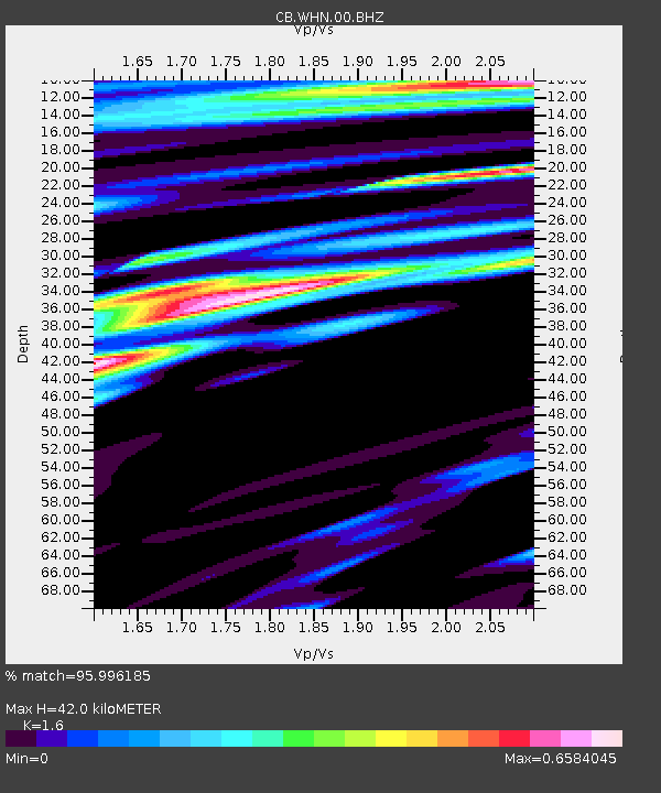
| Estimated Moho Depth: |
42.0 km |
| Estimated Crust Vp/Vs: |
1.60 |
| Assumed Crust Vp: |
6.276 km/s |
| Estimated Crust Vs: |
3.922 km/s |
| Estimated Crust Poisson's Ratio: |
0.18 |
|
| Radial Match: |
95.996185 % |
| Radial Bump: |
323 |
| Transverse Match: |
87.33042 % |
| Transverse Bump: |
400 |
| SOD ConfigId: |
13570011 |
| Insert Time: |
2019-05-01 23:36:54.156 +0000 |
| GWidth: |
2.5 |
| Max Bumps: |
400 |
| Tol: |
0.001 |
|

Signal To Noise
| Channel | StoN | STA | LTA |
| CB:WHN:00:BHZ:20181201T13:34:13.289999Z | 59.626938 | 8.852559E-6 | 1.4846577E-7 |
| CB:WHN:00:BHN:20181201T13:34:13.289999Z | 15.993133 | 3.08306E-6 | 1.92774E-7 |
| CB:WHN:00:BHE:20181201T13:34:13.289999Z | 11.00276 | 1.5798814E-6 | 1.4358956E-7 |
| Arrivals |
| Ps | 4.3 SECOND |
| PpPs | 16 SECOND |
| PsPs/PpSs | 20 SECOND |


