You are here: Home > Network List > TS - TERRAscope (Southern California Seismic Network) Stations List
> Station BAR Barrett Dam, California, USA > Earthquake Result Viewer
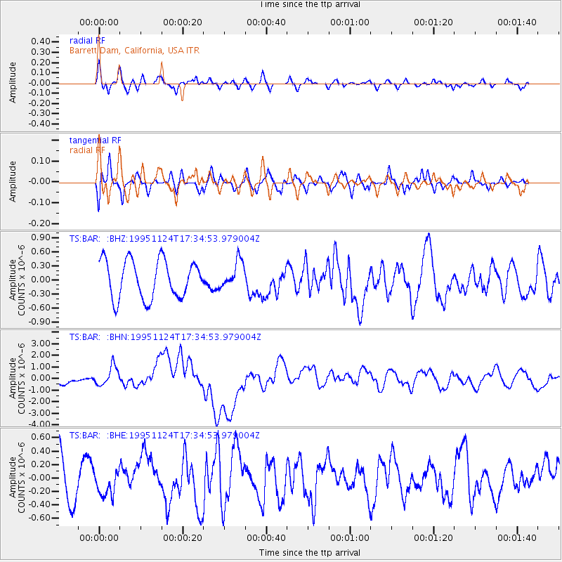
BAR Barrett Dam, California, USA - Earthquake Result Viewer
*The percent match for this event was below the threshold and hence no stack was calculated.
| Earthquake location: |
Kuril Islands |
| Earthquake latitude/longitude: |
44.5/149.1 |
| Earthquake time(UTC): |
1995/11/24 (328) 17:24:12 GMT |
| Earthquake Depth: |
33 km |
| Earthquake Magnitude: |
6.1 MB, 6.3 MS, 6.1 UNKNOWN, 6.6 MW |
| Earthquake Catalog/Contributor: |
WHDF/NEIC |
|
| Network: |
TS TERRAscope (Southern California Seismic Network) |
| Station: |
BAR Barrett Dam, California, USA |
| Lat/Lon: |
32.68 N/116.67 W |
| Elevation: |
548 m |
|
| Distance: |
70.7 deg |
| Az: |
63.038 deg |
| Baz: |
310.908 deg |
| Ray Param: |
$rayparam |
*The percent match for this event was below the threshold and hence was not used in the summary stack. |
|
| Radial Match: |
58.827972 % |
| Radial Bump: |
400 |
| Transverse Match: |
51.22791 % |
| Transverse Bump: |
400 |
| SOD ConfigId: |
4480 |
| Insert Time: |
2010-02-26 14:01:29.372 +0000 |
| GWidth: |
2.5 |
| Max Bumps: |
400 |
| Tol: |
0.001 |
|
Signal To Noise
| Channel | StoN | STA | LTA |
| TS:BAR: :BHN:19951124T17:34:53.979004Z | 2.1252987 | 8.1583335E-7 | 3.8386762E-7 |
| TS:BAR: :BHE:19951124T17:34:53.979004Z | 0.5582113 | 1.6833675E-7 | 3.0156457E-7 |
| TS:BAR: :BHZ:19951124T17:34:53.979004Z | 0.72763187 | 2.9169274E-7 | 4.0087957E-7 |
| Arrivals |
| Ps | |
| PpPs | |
| PsPs/PpSs | |


