You are here: Home > Network List > TA - USArray Transportable Network (new EarthScope stations) Stations List
> Station P13A Bates Ranch, Gandy, UT, USA > Earthquake Result Viewer
P13A Bates Ranch, Gandy, UT, USA - Earthquake Result Viewer

| Earthquake location: |
Eastern Honshu, Japan |
| Earthquake latitude/longitude: |
39.8/141.5 |
| Earthquake time(UTC): |
2008/07/23 (205) 15:26:19 GMT |
| Earthquake Depth: |
108 km |
| Earthquake Magnitude: |
6.6 MB, 6.8 MW, 6.8 MW |
| Earthquake Catalog/Contributor: |
WHDF/NEIC |
|
| Network: |
TA USArray Transportable Network (new EarthScope stations) |
| Station: |
P13A Bates Ranch, Gandy, UT, USA |
| Lat/Lon: |
39.46 N/114.02 W |
| Elevation: |
1555 m |
|
| Distance: |
75.3 deg |
| Az: |
50.796 deg |
| Baz: |
309.551 deg |
| Ray Param: |
0.051513597 |
| Estimated Moho Depth: |
30.25 km |
| Estimated Crust Vp/Vs: |
1.80 |
| Assumed Crust Vp: |
6.276 km/s |
| Estimated Crust Vs: |
3.496 km/s |
| Estimated Crust Poisson's Ratio: |
0.27 |
|
| Radial Match: |
97.54252 % |
| Radial Bump: |
362 |
| Transverse Match: |
95.92672 % |
| Transverse Bump: |
400 |
| SOD ConfigId: |
2504 |
| Insert Time: |
2010-03-06 18:26:29.142 +0000 |
| GWidth: |
2.5 |
| Max Bumps: |
400 |
| Tol: |
0.001 |
|
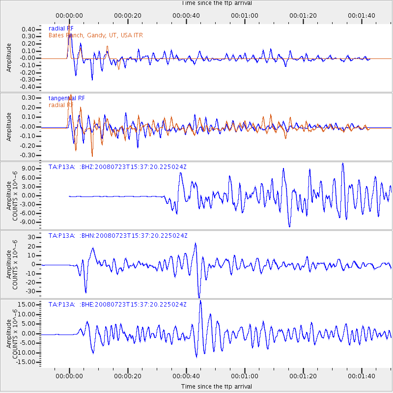
Signal To Noise
| Channel | StoN | STA | LTA |
| TA:P13A: :BHN:20080723T15:37:20.225024Z | 23.552431 | 4.133521E-6 | 1.7550295E-7 |
| TA:P13A: :BHE:20080723T15:37:20.225024Z | 11.9202385 | 1.0969372E-6 | 9.202309E-8 |
| TA:P13A: :BHZ:20080723T15:37:20.225024Z | 14.476505 | 1.0276071E-6 | 7.098448E-8 |
| Arrivals |
| Ps | 3.9 SECOND |
| PpPs | 13 SECOND |
| PsPs/PpSs | 17 SECOND |


