You are here: Home > Network List > TA - USArray Transportable Network (new EarthScope stations) Stations List
> Station P13A Bates Ranch, Gandy, UT, USA > Earthquake Result Viewer
P13A Bates Ranch, Gandy, UT, USA - Earthquake Result Viewer
| Earthquake location: |
Solomon Islands |
| Earthquake latitude/longitude: |
-8.5/157.0 |
| Earthquake time(UTC): |
2007/04/01 (091) 20:39:56 GMT |
| Earthquake Depth: |
10 km |
| Earthquake Magnitude: |
6.8 MB, 7.9 MS, 8.1 MW, 7.7 ME |
| Earthquake Catalog/Contributor: |
WHDF/NEIC |
|
| Network: |
TA USArray Transportable Network (new EarthScope stations) |
| Station: |
P13A Bates Ranch, Gandy, UT, USA |
| Lat/Lon: |
39.46 N/114.02 W |
| Elevation: |
1555 m |
|
| Distance: |
94.5 deg |
| Az: |
50.938 deg |
| Baz: |
262.812 deg |
| Ray Param: |
0.04103056 |
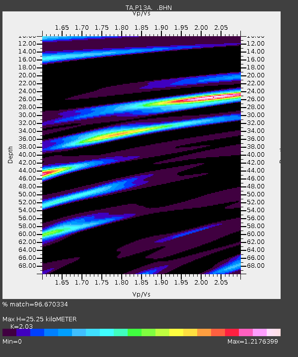
| Estimated Moho Depth: |
25.25 km |
| Estimated Crust Vp/Vs: |
2.03 |
| Assumed Crust Vp: |
6.276 km/s |
| Estimated Crust Vs: |
3.092 km/s |
| Estimated Crust Poisson's Ratio: |
0.34 |
|
| Radial Match: |
96.670334 % |
| Radial Bump: |
400 |
| Transverse Match: |
86.76602 % |
| Transverse Bump: |
400 |
| SOD ConfigId: |
2564 |
| Insert Time: |
2010-03-06 18:27:36.837 +0000 |
| GWidth: |
2.5 |
| Max Bumps: |
400 |
| Tol: |
0.001 |
|
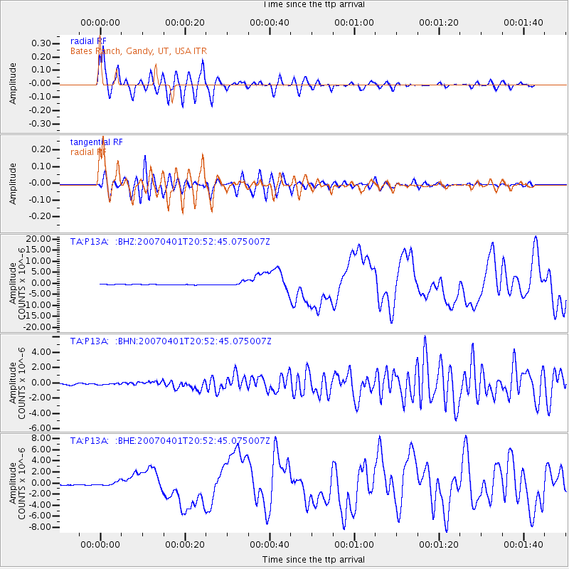
Signal To Noise
| Channel | StoN | STA | LTA |
| TA:P13A: :BHN:20070401T20:52:45.075007Z | 0.9045422 | 8.040215E-8 | 8.888712E-8 |
| TA:P13A: :BHE:20070401T20:52:45.075007Z | 3.03105 | 3.7112412E-7 | 1.2244078E-7 |
| TA:P13A: :BHZ:20070401T20:52:45.075007Z | 6.854786 | 9.893012E-7 | 1.4432268E-7 |
| Arrivals |
| Ps | 4.2 SECOND |
| PpPs | 12 SECOND |
| PsPs/PpSs | 16 SECOND |


