You are here: Home > Network List > TA - USArray Transportable Network (new EarthScope stations) Stations List
> Station P13A Bates Ranch, Gandy, UT, USA > Earthquake Result Viewer
P13A Bates Ranch, Gandy, UT, USA - Earthquake Result Viewer
| Earthquake location: |
Loyalty Islands |
| Earthquake latitude/longitude: |
-20.1/168.9 |
| Earthquake time(UTC): |
2008/04/09 (100) 12:46:12 GMT |
| Earthquake Depth: |
33 km |
| Earthquake Magnitude: |
6.3 MB, 7.3 MS, 7.3 MW, 7.3 MW |
| Earthquake Catalog/Contributor: |
WHDF/NEIC |
|
| Network: |
TA USArray Transportable Network (new EarthScope stations) |
| Station: |
P13A Bates Ranch, Gandy, UT, USA |
| Lat/Lon: |
39.46 N/114.02 W |
| Elevation: |
1555 m |
|
| Distance: |
93.1 deg |
| Az: |
49.089 deg |
| Baz: |
246.572 deg |
| Ray Param: |
0.041324828 |
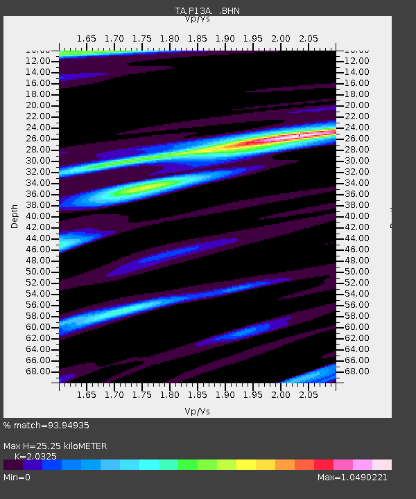
| Estimated Moho Depth: |
25.25 km |
| Estimated Crust Vp/Vs: |
2.03 |
| Assumed Crust Vp: |
6.276 km/s |
| Estimated Crust Vs: |
3.088 km/s |
| Estimated Crust Poisson's Ratio: |
0.34 |
|
| Radial Match: |
93.94935 % |
| Radial Bump: |
400 |
| Transverse Match: |
86.735985 % |
| Transverse Bump: |
400 |
| SOD ConfigId: |
2504 |
| Insert Time: |
2010-03-06 18:27:42.230 +0000 |
| GWidth: |
2.5 |
| Max Bumps: |
400 |
| Tol: |
0.001 |
|

Signal To Noise
| Channel | StoN | STA | LTA |
| TA:P13A: :BHN:20080409T12:58:51.699004Z | 3.5876067 | 9.600016E-7 | 2.6758832E-7 |
| TA:P13A: :BHE:20080409T12:58:51.699004Z | 1.605192 | 2.1057146E-7 | 1.311815E-7 |
| TA:P13A: :BHZ:20080409T12:58:51.699004Z | 2.2096567 | 5.625844E-7 | 2.546026E-7 |
| Arrivals |
| Ps | 4.2 SECOND |
| PpPs | 12 SECOND |
| PsPs/PpSs | 16 SECOND |


