You are here: Home > Network List > TA - USArray Transportable Network (new EarthScope stations) Stations List
> Station P13A Bates Ranch, Gandy, UT, USA > Earthquake Result Viewer
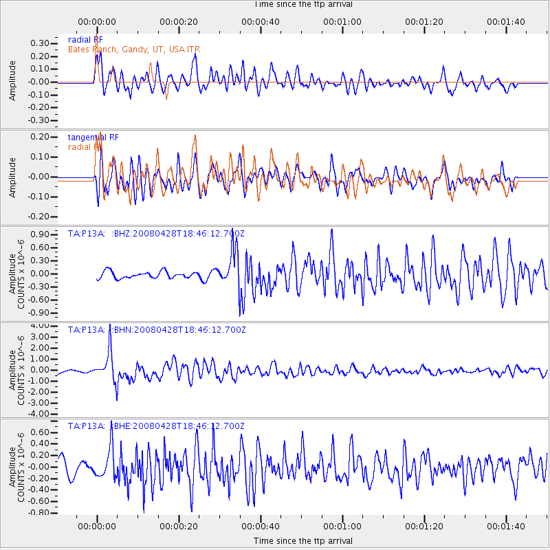
P13A Bates Ranch, Gandy, UT, USA - Earthquake Result Viewer
*The percent match for this event was below the threshold and hence no stack was calculated.
| Earthquake location: |
Vanuatu Islands |
| Earthquake latitude/longitude: |
-19.9/169.0 |
| Earthquake time(UTC): |
2008/04/28 (119) 18:33:34 GMT |
| Earthquake Depth: |
32 km |
| Earthquake Magnitude: |
6.2 MB, 6.2 MS, 6.4 MW, 6.4 MW |
| Earthquake Catalog/Contributor: |
WHDF/NEIC |
|
| Network: |
TA USArray Transportable Network (new EarthScope stations) |
| Station: |
P13A Bates Ranch, Gandy, UT, USA |
| Lat/Lon: |
39.46 N/114.02 W |
| Elevation: |
1555 m |
|
| Distance: |
92.9 deg |
| Az: |
49.065 deg |
| Baz: |
246.632 deg |
| Ray Param: |
$rayparam |
*The percent match for this event was below the threshold and hence was not used in the summary stack. |
|
| Radial Match: |
81.70331 % |
| Radial Bump: |
400 |
| Transverse Match: |
78.80239 % |
| Transverse Bump: |
400 |
| SOD ConfigId: |
2504 |
| Insert Time: |
2010-03-06 18:28:32.580 +0000 |
| GWidth: |
2.5 |
| Max Bumps: |
400 |
| Tol: |
0.001 |
|
Signal To Noise
| Channel | StoN | STA | LTA |
| TA:P13A: :BHN:20080428T18:46:12.700Z | 11.493481 | 1.3913491E-6 | 1.210555E-7 |
| TA:P13A: :BHE:20080428T18:46:12.700Z | 2.5772958 | 2.7543183E-7 | 1.06868534E-7 |
| TA:P13A: :BHZ:20080428T18:46:12.700Z | 5.522752 | 4.210506E-7 | 7.6239274E-8 |
| Arrivals |
| Ps | |
| PpPs | |
| PsPs/PpSs | |


