You are here: Home > Network List > TA - USArray Transportable Network (new EarthScope stations) Stations List
> Station G16K Koyuk River, AK, USA > Earthquake Result Viewer
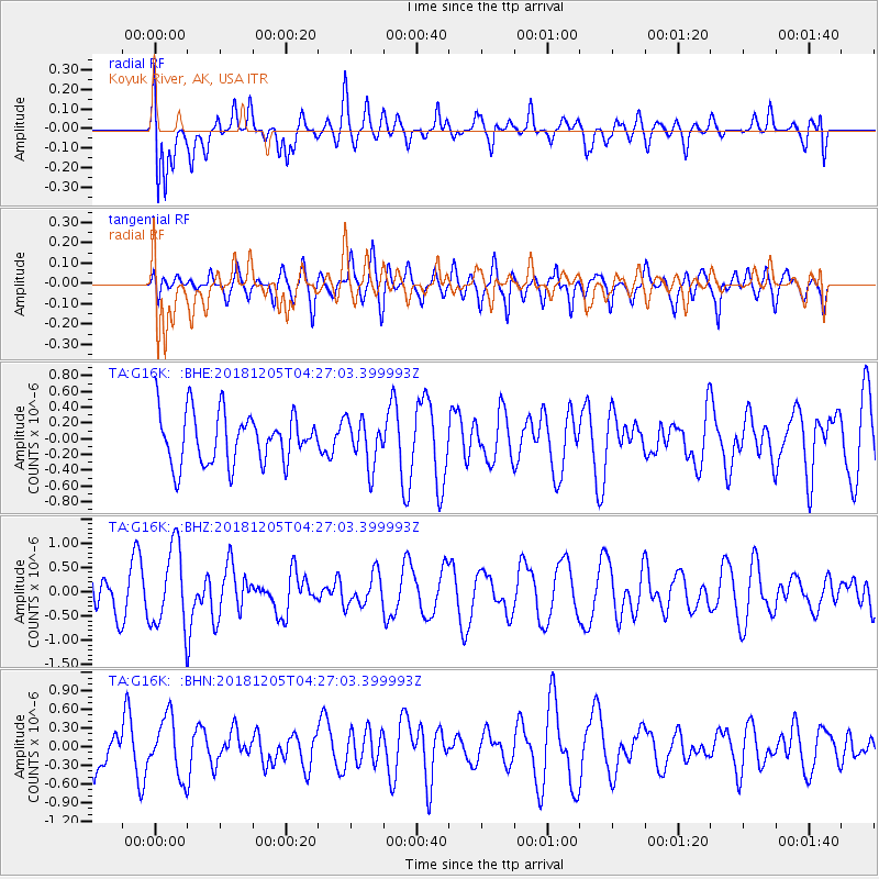
G16K Koyuk River, AK, USA - Earthquake Result Viewer
*The percent match for this event was below the threshold and hence no stack was calculated.
| Earthquake location: |
Southeast Of Loyalty Islands |
| Earthquake latitude/longitude: |
-22.0/169.3 |
| Earthquake time(UTC): |
2018/12/05 (339) 04:14:36 GMT |
| Earthquake Depth: |
10 km |
| Earthquake Magnitude: |
6.0 mb |
| Earthquake Catalog/Contributor: |
NEIC PDE/us |
|
| Network: |
TA USArray Transportable Network (new EarthScope stations) |
| Station: |
G16K Koyuk River, AK, USA |
| Lat/Lon: |
65.39 N/162.35 W |
| Elevation: |
169 m |
|
| Distance: |
89.8 deg |
| Az: |
11.461 deg |
| Baz: |
206.133 deg |
| Ray Param: |
$rayparam |
*The percent match for this event was below the threshold and hence was not used in the summary stack. |
|
| Radial Match: |
70.96713 % |
| Radial Bump: |
400 |
| Transverse Match: |
42.44599 % |
| Transverse Bump: |
400 |
| SOD ConfigId: |
13570011 |
| Insert Time: |
2019-05-02 00:06:21.725 +0000 |
| GWidth: |
2.5 |
| Max Bumps: |
400 |
| Tol: |
0.001 |
|
Signal To Noise
| Channel | StoN | STA | LTA |
| TA:G16K: :BHZ:20181205T04:27:03.399993Z | 2.824066 | 8.224333E-7 | 2.9122313E-7 |
| TA:G16K: :BHN:20181205T04:27:03.399993Z | 2.0213857 | 4.6701626E-7 | 2.3103769E-7 |
| TA:G16K: :BHE:20181205T04:27:03.399993Z | 0.9058944 | 2.920491E-7 | 3.2238756E-7 |
| Arrivals |
| Ps | |
| PpPs | |
| PsPs/PpSs | |


