You are here: Home > Network List > TA - USArray Transportable Network (new EarthScope stations) Stations List
> Station P13A Bates Ranch, Gandy, UT, USA > Earthquake Result Viewer
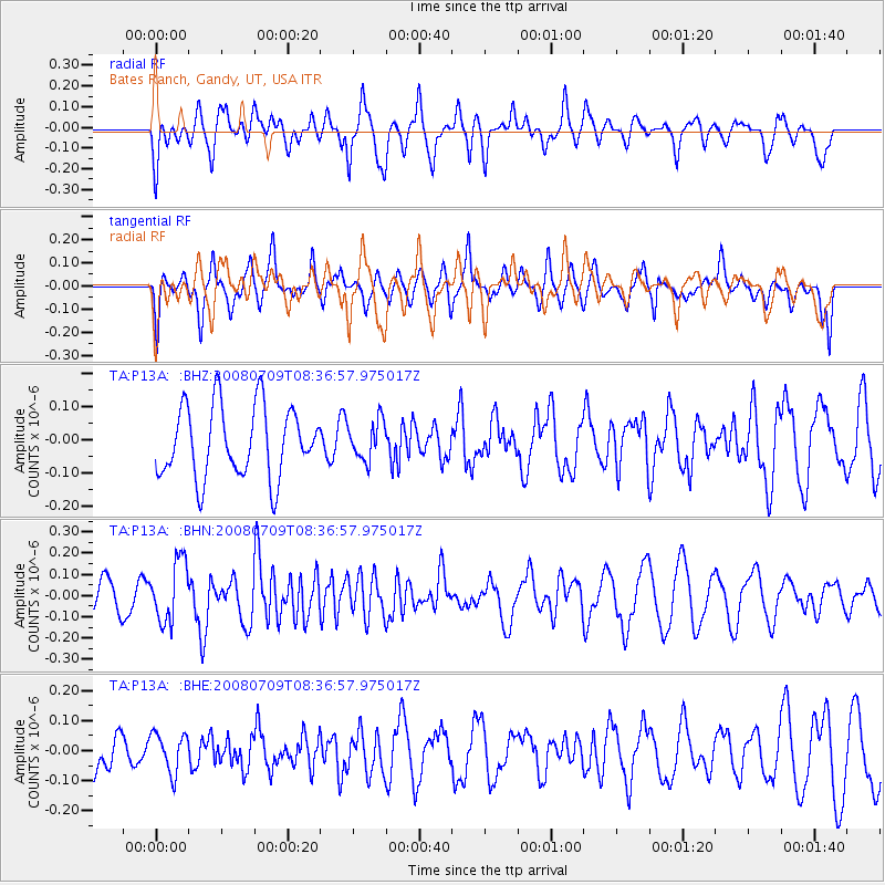
P13A Bates Ranch, Gandy, UT, USA - Earthquake Result Viewer
*The percent match for this event was below the threshold and hence no stack was calculated.
| Earthquake location: |
Loyalty Islands |
| Earthquake latitude/longitude: |
-20.9/168.8 |
| Earthquake time(UTC): |
2008/07/09 (191) 08:24:16 GMT |
| Earthquake Depth: |
39 km |
| Earthquake Magnitude: |
5.6 MB, 4.9 MS, 5.4 MW |
| Earthquake Catalog/Contributor: |
WHDF/NEIC |
|
| Network: |
TA USArray Transportable Network (new EarthScope stations) |
| Station: |
P13A Bates Ranch, Gandy, UT, USA |
| Lat/Lon: |
39.46 N/114.02 W |
| Elevation: |
1555 m |
|
| Distance: |
93.7 deg |
| Az: |
49.165 deg |
| Baz: |
246.009 deg |
| Ray Param: |
$rayparam |
*The percent match for this event was below the threshold and hence was not used in the summary stack. |
|
| Radial Match: |
56.184727 % |
| Radial Bump: |
400 |
| Transverse Match: |
66.42857 % |
| Transverse Bump: |
377 |
| SOD ConfigId: |
2504 |
| Insert Time: |
2010-03-06 18:28:42.255 +0000 |
| GWidth: |
2.5 |
| Max Bumps: |
400 |
| Tol: |
0.001 |
|
Signal To Noise
| Channel | StoN | STA | LTA |
| TA:P13A: :BHN:20080709T08:36:57.975017Z | 1.7507918 | 1.4347214E-7 | 8.1947E-8 |
| TA:P13A: :BHE:20080709T08:36:57.975017Z | 0.8406388 | 6.570875E-8 | 7.816525E-8 |
| TA:P13A: :BHZ:20080709T08:36:57.975017Z | 0.5449997 | 5.7914562E-8 | 1.0626531E-7 |
| Arrivals |
| Ps | |
| PpPs | |
| PsPs/PpSs | |


