You are here: Home > Network List > YT07 - POLENET Stations List
> Station THUR THUR > Earthquake Result Viewer
THUR THUR - Earthquake Result Viewer
| Earthquake location: |
Southeast Of Loyalty Islands |
| Earthquake latitude/longitude: |
-22.0/169.3 |
| Earthquake time(UTC): |
2018/12/05 (339) 04:14:36 GMT |
| Earthquake Depth: |
10 km |
| Earthquake Magnitude: |
6.0 mb |
| Earthquake Catalog/Contributor: |
NEIC PDE/us |
|
| Network: |
YT POLENET |
| Station: |
THUR THUR |
| Lat/Lon: |
72.53 S/97.56 W |
| Elevation: |
239 m |
|
| Distance: |
70.2 deg |
| Az: |
161.298 deg |
| Baz: |
260.168 deg |
| Ray Param: |
0.055171154 |
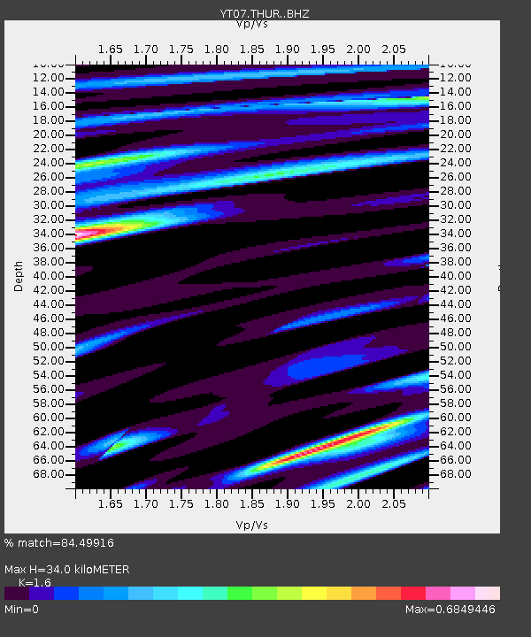
| Estimated Moho Depth: |
34.0 km |
| Estimated Crust Vp/Vs: |
1.60 |
| Assumed Crust Vp: |
6.43 km/s |
| Estimated Crust Vs: |
4.019 km/s |
| Estimated Crust Poisson's Ratio: |
0.18 |
|
| Radial Match: |
84.49916 % |
| Radial Bump: |
400 |
| Transverse Match: |
73.452385 % |
| Transverse Bump: |
400 |
| SOD ConfigId: |
13570011 |
| Insert Time: |
2019-05-02 00:07:45.796 +0000 |
| GWidth: |
2.5 |
| Max Bumps: |
400 |
| Tol: |
0.001 |
|

Signal To Noise
| Channel | StoN | STA | LTA |
| YT:THUR: :BHZ:20181205T04:25:17.850005Z | 8.715939 | 5.863303E-7 | 6.7271046E-8 |
| YT:THUR: :BHN:20181205T04:25:17.850005Z | 3.2465925 | 1.9438981E-7 | 5.987503E-8 |
| YT:THUR: :BHE:20181205T04:25:17.850005Z | 3.6337879 | 2.0765438E-7 | 5.7145435E-8 |
| Arrivals |
| Ps | 3.3 SECOND |
| PpPs | 13 SECOND |
| PsPs/PpSs | 17 SECOND |


