You are here: Home > Network List > AE - Arizona Broadband Seismic Network Stations List
> Station BARN Flagstaff > Earthquake Result Viewer
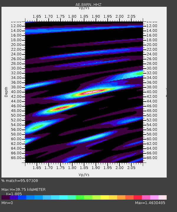
BARN Flagstaff - Earthquake Result Viewer
| Earthquake location: |
Southeast Of Loyalty Islands |
| Earthquake latitude/longitude: |
-22.0/169.4 |
| Earthquake time(UTC): |
2018/12/05 (339) 04:18:08 GMT |
| Earthquake Depth: |
10 km |
| Earthquake Magnitude: |
7.5 Mww |
| Earthquake Catalog/Contributor: |
NEIC PDE/us |
|
| Network: |
AE Arizona Broadband Seismic Network |
| Station: |
BARN Flagstaff |
| Lat/Lon: |
35.28 N/111.74 W |
| Elevation: |
2254 m |
|
| Distance: |
93.8 deg |
| Az: |
53.557 deg |
| Baz: |
245.875 deg |
| Ray Param: |
0.041185934 |
| Estimated Moho Depth: |
39.75 km |
| Estimated Crust Vp/Vs: |
1.88 |
| Assumed Crust Vp: |
6.207 km/s |
| Estimated Crust Vs: |
3.293 km/s |
| Estimated Crust Poisson's Ratio: |
0.30 |
|
| Radial Match: |
95.97309 % |
| Radial Bump: |
400 |
| Transverse Match: |
83.56453 % |
| Transverse Bump: |
400 |
| SOD ConfigId: |
13570011 |
| Insert Time: |
2019-05-02 00:08:43.024 +0000 |
| GWidth: |
2.5 |
| Max Bumps: |
400 |
| Tol: |
0.001 |
|

Signal To Noise
| Channel | StoN | STA | LTA |
| AE:BARN: :HHZ:20181205T04:30:54.069006Z | 3.446951 | 7.3141143E-7 | 2.1219086E-7 |
| AE:BARN: :HHN:20181205T04:30:54.069006Z | 0.69333494 | 2.5349755E-7 | 3.6562062E-7 |
| AE:BARN: :HHE:20181205T04:30:54.069006Z | 1.8614365 | 2.7291887E-7 | 1.4661734E-7 |
| Arrivals |
| Ps | 5.8 SECOND |
| PpPs | 18 SECOND |
| PsPs/PpSs | 24 SECOND |


