You are here: Home > Network List > AK - Alaska Regional Network Stations List
> Station BRSE Bradley Lake South, AK, USA > Earthquake Result Viewer
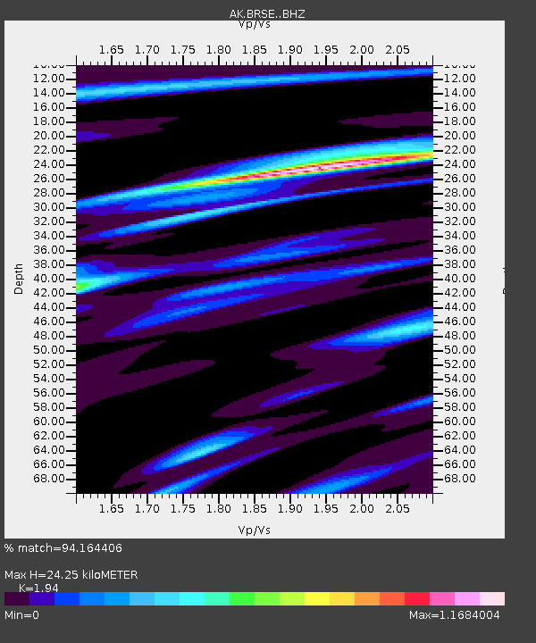
BRSE Bradley Lake South, AK, USA - Earthquake Result Viewer
| Earthquake location: |
Southeast Of Loyalty Islands |
| Earthquake latitude/longitude: |
-22.0/169.4 |
| Earthquake time(UTC): |
2018/12/05 (339) 04:18:08 GMT |
| Earthquake Depth: |
10 km |
| Earthquake Magnitude: |
7.5 Mww |
| Earthquake Catalog/Contributor: |
NEIC PDE/us |
|
| Network: |
AK Alaska Regional Network |
| Station: |
BRSE Bradley Lake South, AK, USA |
| Lat/Lon: |
59.74 N/150.74 W |
| Elevation: |
541 m |
|
| Distance: |
87.7 deg |
| Az: |
18.936 deg |
| Baz: |
216.5 deg |
| Ray Param: |
0.043145936 |
| Estimated Moho Depth: |
24.25 km |
| Estimated Crust Vp/Vs: |
1.94 |
| Assumed Crust Vp: |
6.24 km/s |
| Estimated Crust Vs: |
3.216 km/s |
| Estimated Crust Poisson's Ratio: |
0.32 |
|
| Radial Match: |
94.164406 % |
| Radial Bump: |
400 |
| Transverse Match: |
81.82232 % |
| Transverse Bump: |
400 |
| SOD ConfigId: |
13570011 |
| Insert Time: |
2019-05-02 00:08:59.560 +0000 |
| GWidth: |
2.5 |
| Max Bumps: |
400 |
| Tol: |
0.001 |
|

Signal To Noise
| Channel | StoN | STA | LTA |
| AK:BRSE: :BHZ:20181205T04:30:25.527991Z | 2.720342 | 2.3592854E-6 | 8.6727533E-7 |
| AK:BRSE: :BHN:20181205T04:30:25.527991Z | 1.2425351 | 8.290732E-7 | 6.672433E-7 |
| AK:BRSE: :BHE:20181205T04:30:25.527991Z | 2.2292643 | 1.4267141E-6 | 6.399933E-7 |
| Arrivals |
| Ps | 3.7 SECOND |
| PpPs | 11 SECOND |
| PsPs/PpSs | 15 SECOND |


