You are here: Home > Network List > AU - Australian Seismological Centre Stations List
> Station BLDU Ballidu, Western Australia > Earthquake Result Viewer
BLDU Ballidu, Western Australia - Earthquake Result Viewer
| Earthquake location: |
Southeast Of Loyalty Islands |
| Earthquake latitude/longitude: |
-22.0/169.4 |
| Earthquake time(UTC): |
2018/12/05 (339) 04:18:08 GMT |
| Earthquake Depth: |
10 km |
| Earthquake Magnitude: |
7.5 Mww |
| Earthquake Catalog/Contributor: |
NEIC PDE/us |
|
| Network: |
AU Australian Seismological Centre |
| Station: |
BLDU Ballidu, Western Australia |
| Lat/Lon: |
30.61 S/116.71 E |
| Elevation: |
280 m |
|
| Distance: |
47.7 deg |
| Az: |
248.07 deg |
| Baz: |
92.778 deg |
| Ray Param: |
0.06982231 |
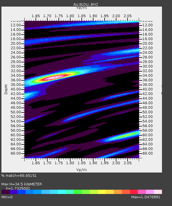
| Estimated Moho Depth: |
34.5 km |
| Estimated Crust Vp/Vs: |
1.73 |
| Assumed Crust Vp: |
6.419 km/s |
| Estimated Crust Vs: |
3.705 km/s |
| Estimated Crust Poisson's Ratio: |
0.25 |
|
| Radial Match: |
98.65151 % |
| Radial Bump: |
198 |
| Transverse Match: |
95.743 % |
| Transverse Bump: |
400 |
| SOD ConfigId: |
13570011 |
| Insert Time: |
2019-05-02 00:09:59.751 +0000 |
| GWidth: |
2.5 |
| Max Bumps: |
400 |
| Tol: |
0.001 |
|

Signal To Noise
| Channel | StoN | STA | LTA |
| AU:BLDU: :BHZ:20181205T04:26:13.993994Z | 15.567646 | 6.209027E-6 | 3.9884173E-7 |
| AU:BLDU: :BHN:20181205T04:26:13.993994Z | 4.4445004 | 9.3184104E-7 | 2.096616E-7 |
| AU:BLDU: :BHE:20181205T04:26:13.993994Z | 12.9379835 | 4.005136E-6 | 3.0956414E-7 |
| Arrivals |
| Ps | 4.2 SECOND |
| PpPs | 14 SECOND |
| PsPs/PpSs | 18 SECOND |


