You are here: Home > Network List > AU - Australian Seismological Centre Stations List
> Station WRKA Warrakurna, Western Australia > Earthquake Result Viewer
WRKA Warrakurna, Western Australia - Earthquake Result Viewer
| Earthquake location: |
Southeast Of Loyalty Islands |
| Earthquake latitude/longitude: |
-22.0/169.4 |
| Earthquake time(UTC): |
2018/12/05 (339) 04:18:08 GMT |
| Earthquake Depth: |
10 km |
| Earthquake Magnitude: |
7.5 Mww |
| Earthquake Catalog/Contributor: |
NEIC PDE/us |
|
| Network: |
AU Australian Seismological Centre |
| Station: |
WRKA Warrakurna, Western Australia |
| Lat/Lon: |
25.04 S/128.30 E |
| Elevation: |
622 m |
|
| Distance: |
37.8 deg |
| Az: |
257.107 deg |
| Baz: |
94.046 deg |
| Ray Param: |
0.07595463 |
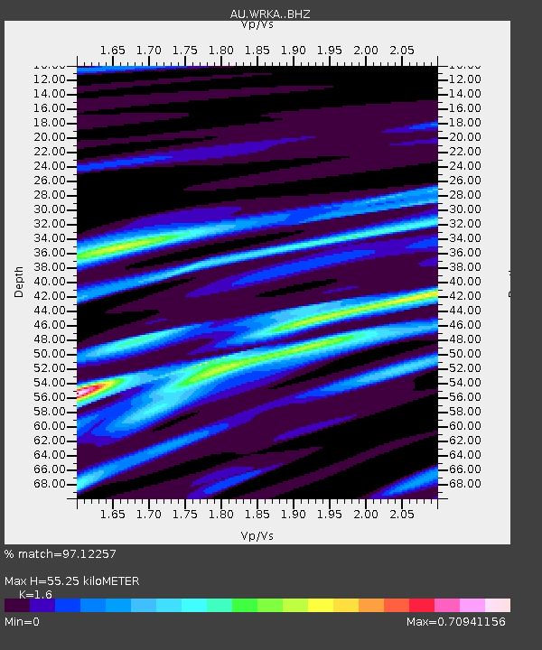
| Estimated Moho Depth: |
55.25 km |
| Estimated Crust Vp/Vs: |
1.60 |
| Assumed Crust Vp: |
6.51 km/s |
| Estimated Crust Vs: |
4.069 km/s |
| Estimated Crust Poisson's Ratio: |
0.18 |
|
| Radial Match: |
97.12257 % |
| Radial Bump: |
219 |
| Transverse Match: |
85.986755 % |
| Transverse Bump: |
400 |
| SOD ConfigId: |
13570011 |
| Insert Time: |
2019-05-02 00:10:10.377 +0000 |
| GWidth: |
2.5 |
| Max Bumps: |
400 |
| Tol: |
0.001 |
|

Signal To Noise
| Channel | StoN | STA | LTA |
| AU:WRKA: :BHZ:20181205T04:24:53.419012Z | 23.504602 | 7.551939E-6 | 3.2129617E-7 |
| AU:WRKA: :BHN:20181205T04:24:53.419012Z | 2.9299874 | 5.45032E-7 | 1.8601854E-7 |
| AU:WRKA: :BHE:20181205T04:24:53.419012Z | 15.468351 | 5.0061535E-6 | 3.236385E-7 |
| Arrivals |
| Ps | 5.5 SECOND |
| PpPs | 20 SECOND |
| PsPs/PpSs | 26 SECOND |


