You are here: Home > Network List > TS - TERRAscope (Southern California Seismic Network) Stations List
> Station BAR Barrett Dam, California, USA > Earthquake Result Viewer
BAR Barrett Dam, California, USA - Earthquake Result Viewer
*The percent match for this event was below the threshold and hence no stack was calculated.
| Earthquake location: |
Bismarck Sea |
| Earthquake latitude/longitude: |
-3.4/146.4 |
| Earthquake time(UTC): |
1996/09/16 (260) 05:47:32 GMT |
| Earthquake Depth: |
33 km |
| Earthquake Magnitude: |
5.5 MB, 5.8 MS, 5.9 UNKNOWN, 5.9 MW |
| Earthquake Catalog/Contributor: |
WHDF/NEIC |
|
| Network: |
TS TERRAscope (Southern California Seismic Network) |
| Station: |
BAR Barrett Dam, California, USA |
| Lat/Lon: |
32.68 N/116.67 W |
| Elevation: |
548 m |
|
| Distance: |
97.7 deg |
| Az: |
57.643 deg |
| Baz: |
270.878 deg |
| Ray Param: |
$rayparam |
*The percent match for this event was below the threshold and hence was not used in the summary stack. |
|
| Radial Match: |
73.20375 % |
| Radial Bump: |
374 |
| Transverse Match: |
60.35978 % |
| Transverse Bump: |
400 |
| SOD ConfigId: |
4480 |
| Insert Time: |
2010-02-26 14:01:32.487 +0000 |
| GWidth: |
2.5 |
| Max Bumps: |
400 |
| Tol: |
0.001 |
|
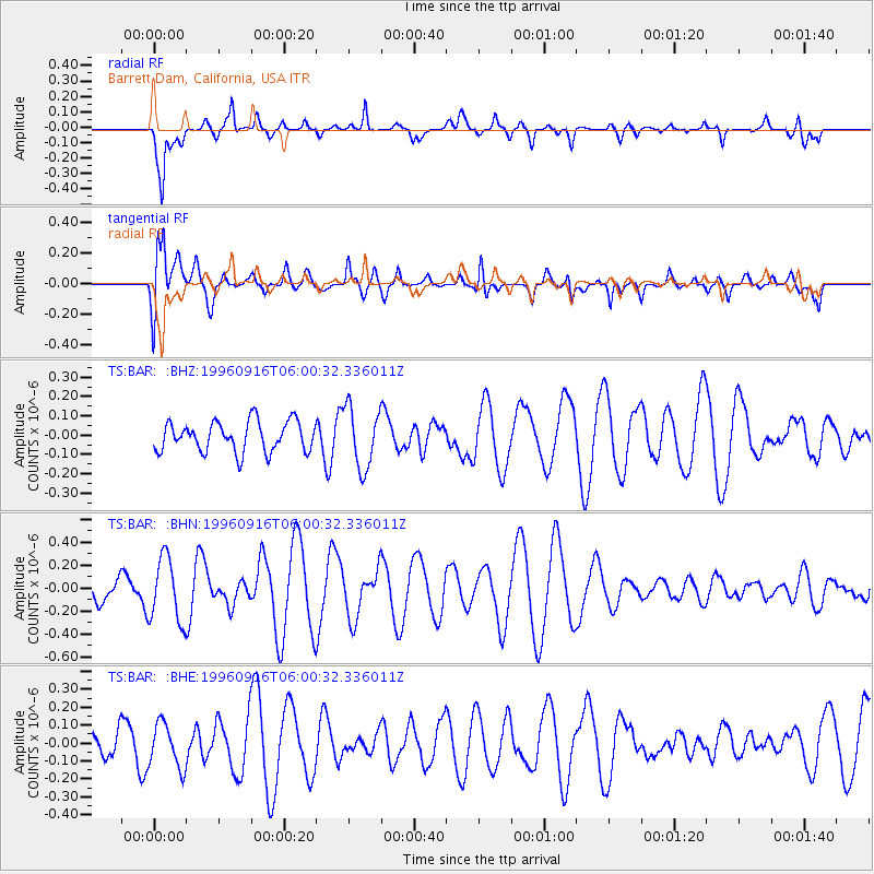
Signal To Noise
| Channel | StoN | STA | LTA |
| TS:BAR: :BHN:19960916T06:00:32.336011Z | 2.7313397 | 2.8148747E-7 | 1.030584E-7 |
| TS:BAR: :BHE:19960916T06:00:32.336011Z | 0.9120174 | 1.2639451E-7 | 1.3858784E-7 |
| TS:BAR: :BHZ:19960916T06:00:32.336011Z | 2.0246258 | 1.5702523E-7 | 7.755766E-8 |
| Arrivals |
| Ps | |
| PpPs | |
| PsPs/PpSs | |


