You are here: Home > Network List > AV - Alaska Volcano Observatory Stations List
> Station STLK Strandline Lake, Regional Station, Alaska > Earthquake Result Viewer
STLK Strandline Lake, Regional Station, Alaska - Earthquake Result Viewer
| Earthquake location: |
Southeast Of Loyalty Islands |
| Earthquake latitude/longitude: |
-22.0/169.4 |
| Earthquake time(UTC): |
2018/12/05 (339) 04:18:08 GMT |
| Earthquake Depth: |
10 km |
| Earthquake Magnitude: |
7.5 Mww |
| Earthquake Catalog/Contributor: |
NEIC PDE/us |
|
| Network: |
AV Alaska Volcano Observatory |
| Station: |
STLK Strandline Lake, Regional Station, Alaska |
| Lat/Lon: |
61.50 N/151.83 W |
| Elevation: |
945 m |
|
| Distance: |
88.8 deg |
| Az: |
17.463 deg |
| Baz: |
215.503 deg |
| Ray Param: |
0.04232058 |
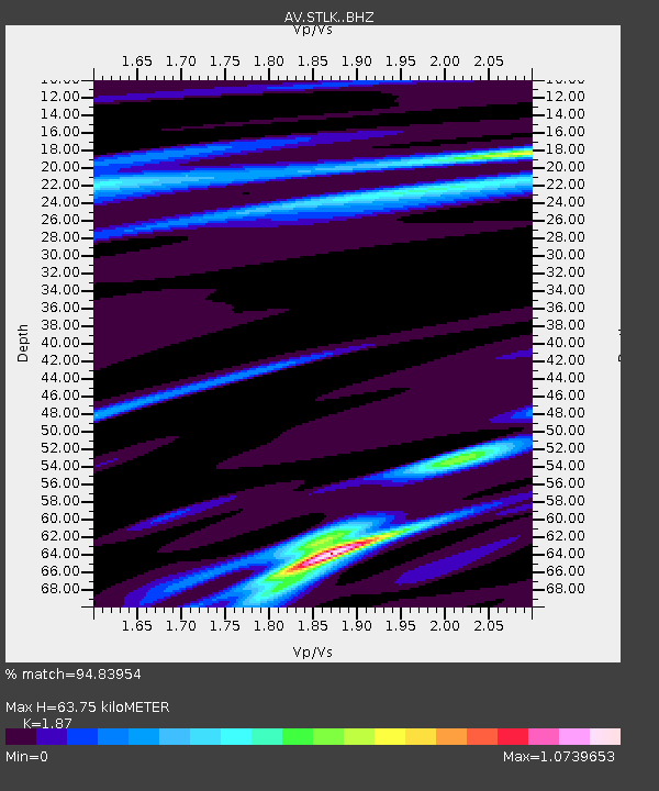
| Estimated Moho Depth: |
63.75 km |
| Estimated Crust Vp/Vs: |
1.87 |
| Assumed Crust Vp: |
6.302 km/s |
| Estimated Crust Vs: |
3.37 km/s |
| Estimated Crust Poisson's Ratio: |
0.30 |
|
| Radial Match: |
94.83954 % |
| Radial Bump: |
400 |
| Transverse Match: |
91.45937 % |
| Transverse Bump: |
400 |
| SOD ConfigId: |
13570011 |
| Insert Time: |
2019-05-02 00:10:34.935 +0000 |
| GWidth: |
2.5 |
| Max Bumps: |
400 |
| Tol: |
0.001 |
|
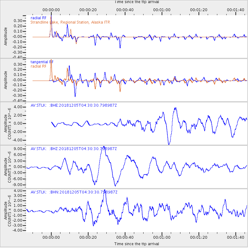
Signal To Noise
| Channel | StoN | STA | LTA |
| AV:STLK: :BHZ:20181205T04:30:30.798987Z | 2.255831 | 6.253997E-7 | 2.7723692E-7 |
| AV:STLK: :BHN:20181205T04:30:30.798987Z | 1.1097121 | 2.6482002E-7 | 2.3863848E-7 |
| AV:STLK: :BHE:20181205T04:30:30.798987Z | 0.6917639 | 2.2550117E-7 | 3.2597995E-7 |
| Arrivals |
| Ps | 9.0 SECOND |
| PpPs | 28 SECOND |
| PsPs/PpSs | 37 SECOND |


