You are here: Home > Network List > AZ - ANZA Regional Network Stations List
> Station RDM AZ.RDM > Earthquake Result Viewer
RDM AZ.RDM - Earthquake Result Viewer

| Earthquake location: |
Southeast Of Loyalty Islands |
| Earthquake latitude/longitude: |
-22.0/169.4 |
| Earthquake time(UTC): |
2018/12/05 (339) 04:18:08 GMT |
| Earthquake Depth: |
10 km |
| Earthquake Magnitude: |
7.5 Mww |
| Earthquake Catalog/Contributor: |
NEIC PDE/us |
|
| Network: |
AZ ANZA Regional Network |
| Station: |
RDM AZ.RDM |
| Lat/Lon: |
33.63 N/116.85 W |
| Elevation: |
1365 m |
|
| Distance: |
89.3 deg |
| Az: |
53.215 deg |
| Baz: |
243.004 deg |
| Ray Param: |
0.041952673 |
| Estimated Moho Depth: |
34.0 km |
| Estimated Crust Vp/Vs: |
1.65 |
| Assumed Crust Vp: |
6.264 km/s |
| Estimated Crust Vs: |
3.785 km/s |
| Estimated Crust Poisson's Ratio: |
0.21 |
|
| Radial Match: |
97.075516 % |
| Radial Bump: |
384 |
| Transverse Match: |
81.52328 % |
| Transverse Bump: |
400 |
| SOD ConfigId: |
13570011 |
| Insert Time: |
2019-05-02 00:10:42.256 +0000 |
| GWidth: |
2.5 |
| Max Bumps: |
400 |
| Tol: |
0.001 |
|
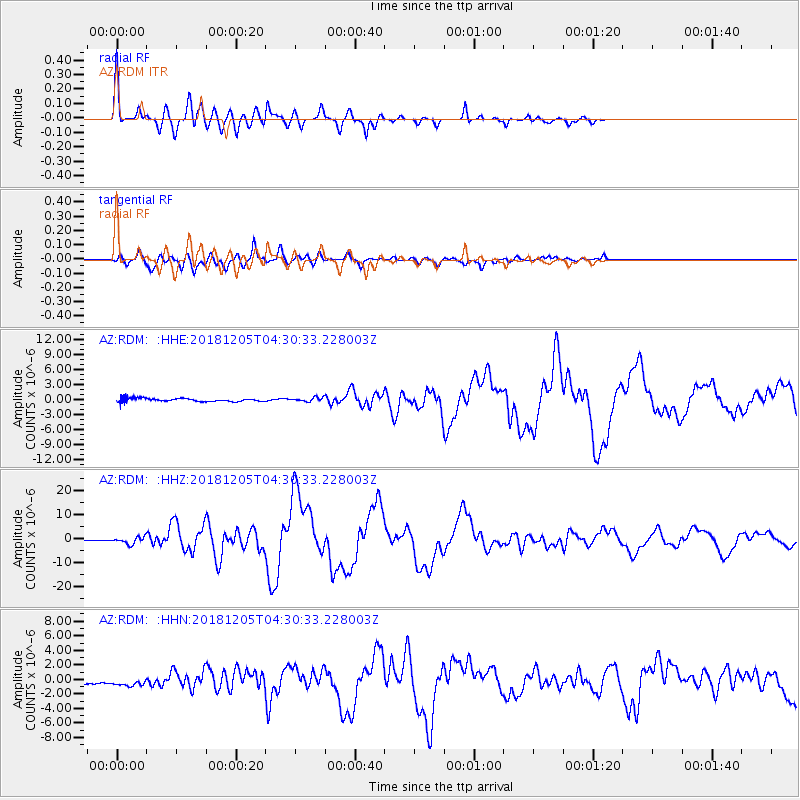
Signal To Noise
| Channel | StoN | STA | LTA |
| AZ:RDM: :HHZ:20181205T04:30:33.228003Z | 9.822721 | 1.415381E-6 | 1.4409257E-7 |
| AZ:RDM: :HHN:20181205T04:30:33.228003Z | 2.1234121 | 7.4437327E-7 | 3.5055524E-7 |
| AZ:RDM: :HHE:20181205T04:30:33.228003Z | 1.1299062 | 3.8251315E-7 | 3.3853533E-7 |
| Arrivals |
| Ps | 3.6 SECOND |
| PpPs | 14 SECOND |
| PsPs/PpSs | 18 SECOND |


