You are here: Home > Network List > TA - USArray Transportable Network (new EarthScope stations) Stations List
> Station O26A Horse Wrangler Ranch, Akron, CO, USA > Earthquake Result Viewer
O26A Horse Wrangler Ranch, Akron, CO, USA - Earthquake Result Viewer

| Earthquake location: |
Kuril Islands |
| Earthquake latitude/longitude: |
46.0/151.4 |
| Earthquake time(UTC): |
2009/04/18 (108) 19:17:58 GMT |
| Earthquake Depth: |
35 km |
| Earthquake Magnitude: |
6.3 MB, 6.3 MS, 6.6 MW, 6.4 MW |
| Earthquake Catalog/Contributor: |
WHDF/NEIC |
|
| Network: |
TA USArray Transportable Network (new EarthScope stations) |
| Station: |
O26A Horse Wrangler Ranch, Akron, CO, USA |
| Lat/Lon: |
40.24 N/103.31 W |
| Elevation: |
1413 m |
|
| Distance: |
71.3 deg |
| Az: |
51.238 deg |
| Baz: |
314.773 deg |
| Ray Param: |
0.054385822 |
| Estimated Moho Depth: |
43.75 km |
| Estimated Crust Vp/Vs: |
1.94 |
| Assumed Crust Vp: |
6.483 km/s |
| Estimated Crust Vs: |
3.337 km/s |
| Estimated Crust Poisson's Ratio: |
0.32 |
|
| Radial Match: |
86.336426 % |
| Radial Bump: |
369 |
| Transverse Match: |
65.959785 % |
| Transverse Bump: |
400 |
| SOD ConfigId: |
2760 |
| Insert Time: |
2010-03-06 18:29:14.465 +0000 |
| GWidth: |
2.5 |
| Max Bumps: |
400 |
| Tol: |
0.001 |
|
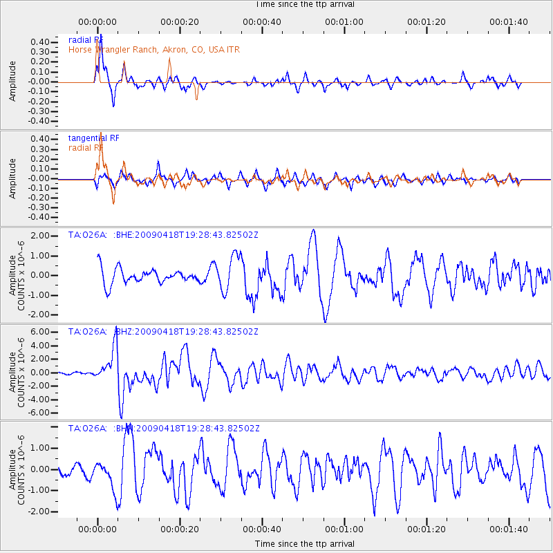
Signal To Noise
| Channel | StoN | STA | LTA |
| TA:O26A: :BHZ:20090418T19:28:43.82502Z | 13.852588 | 2.645364E-6 | 1.9096534E-7 |
| TA:O26A: :BHN:20090418T19:28:43.82502Z | 1.6315931 | 7.0426546E-7 | 4.316428E-7 |
| TA:O26A: :BHE:20090418T19:28:43.82502Z | 2.456714 | 9.182094E-7 | 3.737551E-7 |
| Arrivals |
| Ps | 6.6 SECOND |
| PpPs | 19 SECOND |
| PsPs/PpSs | 26 SECOND |


