You are here: Home > Network List > C - Chilean National Seismic Network Stations List
> Station GO06 Curarrehue (Paso Mamuil Malal), Chile > Earthquake Result Viewer
GO06 Curarrehue (Paso Mamuil Malal), Chile - Earthquake Result Viewer
| Earthquake location: |
Southeast Of Loyalty Islands |
| Earthquake latitude/longitude: |
-22.0/169.4 |
| Earthquake time(UTC): |
2018/12/05 (339) 04:18:08 GMT |
| Earthquake Depth: |
10 km |
| Earthquake Magnitude: |
7.5 Mww |
| Earthquake Catalog/Contributor: |
NEIC PDE/us |
|
| Network: |
C Chilean National Seismic Network |
| Station: |
GO06 Curarrehue (Paso Mamuil Malal), Chile |
| Lat/Lon: |
39.58 S/71.47 W |
| Elevation: |
1250 m |
|
| Distance: |
96.5 deg |
| Az: |
137.181 deg |
| Baz: |
234.728 deg |
| Ray Param: |
0.040507402 |
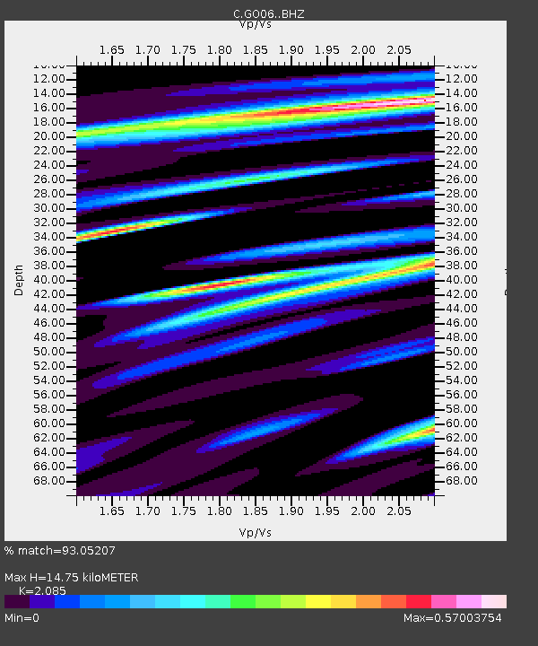
| Estimated Moho Depth: |
14.75 km |
| Estimated Crust Vp/Vs: |
2.09 |
| Assumed Crust Vp: |
6.597 km/s |
| Estimated Crust Vs: |
3.164 km/s |
| Estimated Crust Poisson's Ratio: |
0.35 |
|
| Radial Match: |
93.05207 % |
| Radial Bump: |
400 |
| Transverse Match: |
86.94193 % |
| Transverse Bump: |
400 |
| SOD ConfigId: |
13570011 |
| Insert Time: |
2019-05-02 00:11:02.892 +0000 |
| GWidth: |
2.5 |
| Max Bumps: |
400 |
| Tol: |
0.001 |
|

Signal To Noise
| Channel | StoN | STA | LTA |
| C:GO06: :BHZ:20181205T04:31:06.150Z | 2.2461326 | 1.1334561E-6 | 5.0462563E-7 |
| C:GO06: :BHN:20181205T04:31:06.150Z | 1.0376359 | 4.38428E-7 | 4.2252586E-7 |
| C:GO06: :BHE:20181205T04:31:06.150Z | 1.0630987 | 3.6518946E-7 | 3.435142E-7 |
| Arrivals |
| Ps | 2.5 SECOND |
| PpPs | 6.8 SECOND |
| PsPs/PpSs | 9.2 SECOND |


