You are here: Home > Network List > CC - Cascade Chain Volcano Monitoring Stations List
> Station VALT Mt. St. Helens Crater, WA > Earthquake Result Viewer
VALT Mt. St. Helens Crater, WA - Earthquake Result Viewer
| Earthquake location: |
Southeast Of Loyalty Islands |
| Earthquake latitude/longitude: |
-22.0/169.4 |
| Earthquake time(UTC): |
2018/12/05 (339) 04:18:08 GMT |
| Earthquake Depth: |
10 km |
| Earthquake Magnitude: |
7.5 Mww |
| Earthquake Catalog/Contributor: |
NEIC PDE/us |
|
| Network: |
CC Cascade Chain Volcano Monitoring |
| Station: |
VALT Mt. St. Helens Crater, WA |
| Lat/Lon: |
46.21 N/122.19 W |
| Elevation: |
1681 m |
|
| Distance: |
91.7 deg |
| Az: |
40.222 deg |
| Baz: |
239.683 deg |
| Ray Param: |
0.041567165 |
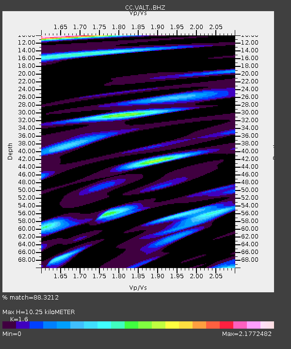
| Estimated Moho Depth: |
10.25 km |
| Estimated Crust Vp/Vs: |
1.60 |
| Assumed Crust Vp: |
6.566 km/s |
| Estimated Crust Vs: |
4.104 km/s |
| Estimated Crust Poisson's Ratio: |
0.18 |
|
| Radial Match: |
88.3212 % |
| Radial Bump: |
400 |
| Transverse Match: |
79.09065 % |
| Transverse Bump: |
400 |
| SOD ConfigId: |
13570011 |
| Insert Time: |
2019-05-02 00:11:37.457 +0000 |
| GWidth: |
2.5 |
| Max Bumps: |
400 |
| Tol: |
0.001 |
|

Signal To Noise
| Channel | StoN | STA | LTA |
| CC:VALT: :BHZ:20181205T04:30:44.42002Z | 6.172215 | 1.9259273E-6 | 3.120318E-7 |
| CC:VALT: :BHN:20181205T04:30:44.42002Z | 1.7326484 | 7.571973E-7 | 4.370173E-7 |
| CC:VALT: :BHE:20181205T04:30:44.42002Z | 2.1756747 | 9.687154E-7 | 4.452483E-7 |
| Arrivals |
| Ps | 1.0 SECOND |
| PpPs | 4.0 SECOND |
| PsPs/PpSs | 4.9 SECOND |


