You are here: Home > Network List > CI - Caltech Regional Seismic Network Stations List
> Station PDM Parker Dam, Lake Havasu City, AZ, USA > Earthquake Result Viewer
PDM Parker Dam, Lake Havasu City, AZ, USA - Earthquake Result Viewer
| Earthquake location: |
Southeast Of Loyalty Islands |
| Earthquake latitude/longitude: |
-22.0/169.4 |
| Earthquake time(UTC): |
2018/12/05 (339) 04:18:08 GMT |
| Earthquake Depth: |
10 km |
| Earthquake Magnitude: |
7.5 Mww |
| Earthquake Catalog/Contributor: |
NEIC PDE/us |
|
| Network: |
CI Caltech Regional Seismic Network |
| Station: |
PDM Parker Dam, Lake Havasu City, AZ, USA |
| Lat/Lon: |
34.30 N/114.14 W |
| Elevation: |
144 m |
|
| Distance: |
91.6 deg |
| Az: |
53.607 deg |
| Baz: |
244.506 deg |
| Ray Param: |
0.041583452 |
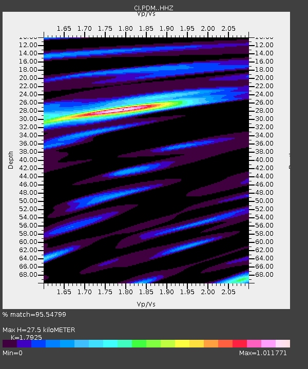
| Estimated Moho Depth: |
27.5 km |
| Estimated Crust Vp/Vs: |
1.79 |
| Assumed Crust Vp: |
6.276 km/s |
| Estimated Crust Vs: |
3.501 km/s |
| Estimated Crust Poisson's Ratio: |
0.27 |
|
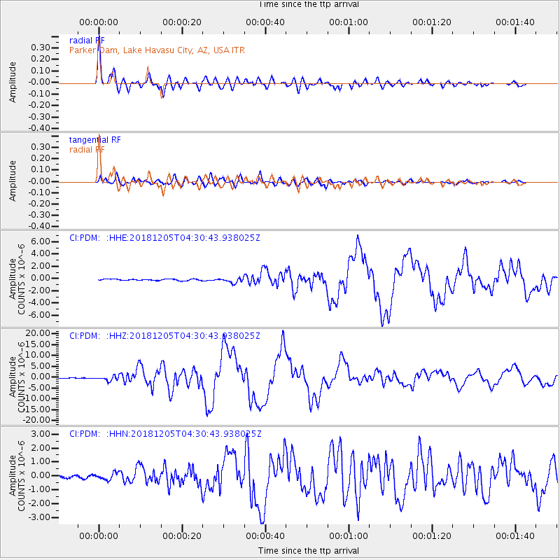
| Radial Match: |
95.54799 % |
| Radial Bump: |
400 |
| Transverse Match: |
90.792625 % |
| Transverse Bump: |
400 |
| SOD ConfigId: |
13570011 |
| Insert Time: |
2019-05-02 00:12:24.210 +0000 |
| GWidth: |
2.5 |
| Max Bumps: |
400 |
| Tol: |
0.001 |
|
Signal To Noise
| Channel | StoN | STA | LTA |
| CI:PDM: :HHZ:20181205T04:30:43.938025Z | 3.868006 | 1.0695439E-6 | 2.765104E-7 |
| CI:PDM: :HHN:20181205T04:30:43.938025Z | 1.3092974 | 2.484411E-7 | 1.8975145E-7 |
| CI:PDM: :HHE:20181205T04:30:43.938025Z | 3.6505246 | 3.9361083E-7 | 1.07823084E-7 |
| Arrivals |
| Ps | 3.5 SECOND |
| PpPs | 12 SECOND |
| PsPs/PpSs | 16 SECOND |


