You are here: Home > Network List > CN - Canadian National Seismograph Network Stations List
> Station BUTB Butedale, BC, CA > Earthquake Result Viewer
BUTB Butedale, BC, CA - Earthquake Result Viewer
| Earthquake location: |
Southeast Of Loyalty Islands |
| Earthquake latitude/longitude: |
-22.0/169.4 |
| Earthquake time(UTC): |
2018/12/05 (339) 04:18:08 GMT |
| Earthquake Depth: |
10 km |
| Earthquake Magnitude: |
7.5 Mww |
| Earthquake Catalog/Contributor: |
NEIC PDE/us |
|
| Network: |
CN Canadian National Seismograph Network |
| Station: |
BUTB Butedale, BC, CA |
| Lat/Lon: |
53.06 N/128.46 W |
| Elevation: |
1094 m |
|
| Distance: |
92.0 deg |
| Az: |
32.251 deg |
| Baz: |
235.162 deg |
| Ray Param: |
0.041529413 |
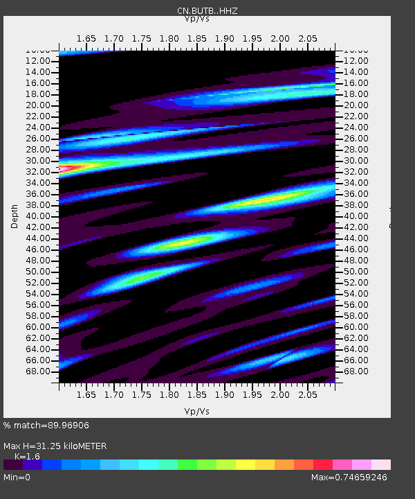
| Estimated Moho Depth: |
31.25 km |
| Estimated Crust Vp/Vs: |
1.60 |
| Assumed Crust Vp: |
6.545 km/s |
| Estimated Crust Vs: |
4.091 km/s |
| Estimated Crust Poisson's Ratio: |
0.18 |
|
| Radial Match: |
89.96906 % |
| Radial Bump: |
400 |
| Transverse Match: |
77.75356 % |
| Transverse Bump: |
400 |
| SOD ConfigId: |
13570011 |
| Insert Time: |
2019-05-02 00:12:47.834 +0000 |
| GWidth: |
2.5 |
| Max Bumps: |
400 |
| Tol: |
0.001 |
|

Signal To Noise
| Channel | StoN | STA | LTA |
| CN:BUTB: :HHZ:20181205T04:30:45.540015Z | 3.0645792 | 1.7564167E-6 | 5.731347E-7 |
| CN:BUTB: :HHN:20181205T04:30:45.540015Z | 1.5631937 | 3.346388E-7 | 2.1407378E-7 |
| CN:BUTB: :HHE:20181205T04:30:45.540015Z | 1.9122725 | 1.1200095E-6 | 5.8569555E-7 |
| Arrivals |
| Ps | 2.9 SECOND |
| PpPs | 12 SECOND |
| PsPs/PpSs | 15 SECOND |


