You are here: Home > Network List > CN - Canadian National Seismograph Network Stations List
> Station DAWY Dawson, YT, CA > Earthquake Result Viewer
DAWY Dawson, YT, CA - Earthquake Result Viewer
| Earthquake location: |
Southeast Of Loyalty Islands |
| Earthquake latitude/longitude: |
-22.0/169.4 |
| Earthquake time(UTC): |
2018/12/05 (339) 04:18:08 GMT |
| Earthquake Depth: |
10 km |
| Earthquake Magnitude: |
7.5 Mww |
| Earthquake Catalog/Contributor: |
NEIC PDE/us |
|
| Network: |
CN Canadian National Seismograph Network |
| Station: |
DAWY Dawson, YT, CA |
| Lat/Lon: |
64.06 N/139.39 W |
| Elevation: |
771 m |
|
| Distance: |
94.5 deg |
| Az: |
20.094 deg |
| Baz: |
226.488 deg |
| Ray Param: |
0.041034415 |
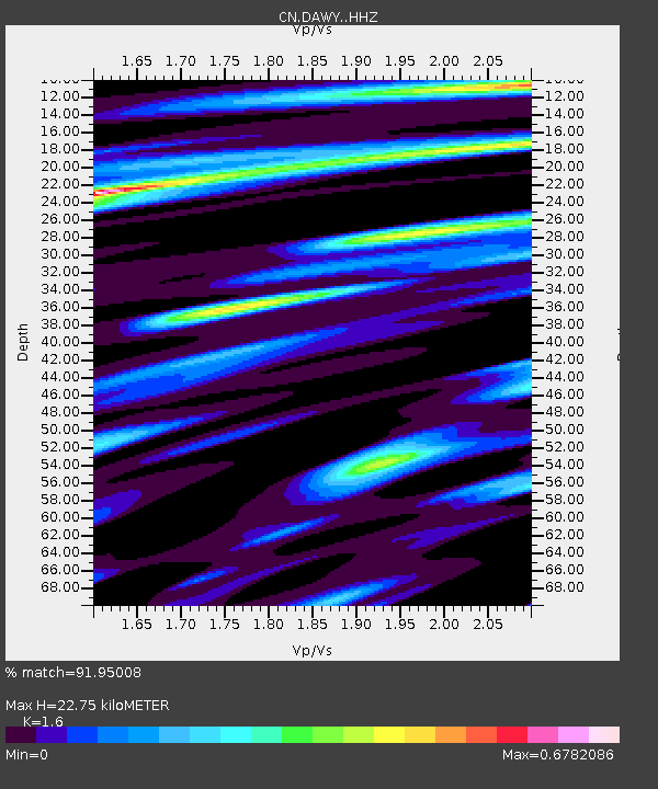
| Estimated Moho Depth: |
22.75 km |
| Estimated Crust Vp/Vs: |
1.60 |
| Assumed Crust Vp: |
6.566 km/s |
| Estimated Crust Vs: |
4.104 km/s |
| Estimated Crust Poisson's Ratio: |
0.18 |
|
| Radial Match: |
91.95008 % |
| Radial Bump: |
400 |
| Transverse Match: |
79.63046 % |
| Transverse Bump: |
400 |
| SOD ConfigId: |
13570011 |
| Insert Time: |
2019-05-02 00:12:49.066 +0000 |
| GWidth: |
2.5 |
| Max Bumps: |
400 |
| Tol: |
0.001 |
|

Signal To Noise
| Channel | StoN | STA | LTA |
| CN:DAWY: :HHZ:20181205T04:30:57.009985Z | 3.207885 | 1.1459623E-6 | 3.5723298E-7 |
| CN:DAWY: :HHN:20181205T04:30:57.009985Z | 1.3649174 | 4.71552E-7 | 3.4548023E-7 |
| CN:DAWY: :HHE:20181205T04:30:57.009985Z | 2.0211308 | 4.4261665E-7 | 2.1899457E-7 |
| Arrivals |
| Ps | 2.1 SECOND |
| PpPs | 8.8 SECOND |
| PsPs/PpSs | 11 SECOND |


