You are here: Home > Network List > HV - Hawaiian Volcano Observatory Network Stations List
> Station MLOD Mauna Loa, Hawaii Digital > Earthquake Result Viewer
MLOD Mauna Loa, Hawaii Digital - Earthquake Result Viewer

| Earthquake location: |
Southeast Of Loyalty Islands |
| Earthquake latitude/longitude: |
-22.0/169.4 |
| Earthquake time(UTC): |
2018/12/05 (339) 04:18:08 GMT |
| Earthquake Depth: |
10 km |
| Earthquake Magnitude: |
7.5 Mww |
| Earthquake Catalog/Contributor: |
NEIC PDE/us |
|
| Network: |
HV Hawaiian Volcano Observatory Network |
| Station: |
MLOD Mauna Loa, Hawaii Digital |
| Lat/Lon: |
19.49 N/155.39 W |
| Elevation: |
2044 m |
|
| Distance: |
53.7 deg |
| Az: |
42.415 deg |
| Baz: |
221.581 deg |
| Ray Param: |
0.065946825 |
| Estimated Moho Depth: |
20.75 km |
| Estimated Crust Vp/Vs: |
1.60 |
| Assumed Crust Vp: |
5.195 km/s |
| Estimated Crust Vs: |
3.247 km/s |
| Estimated Crust Poisson's Ratio: |
0.18 |
|
| Radial Match: |
85.23052 % |
| Radial Bump: |
397 |
| Transverse Match: |
72.34523 % |
| Transverse Bump: |
400 |
| SOD ConfigId: |
13570011 |
| Insert Time: |
2019-05-02 00:13:20.355 +0000 |
| GWidth: |
2.5 |
| Max Bumps: |
400 |
| Tol: |
0.001 |
|
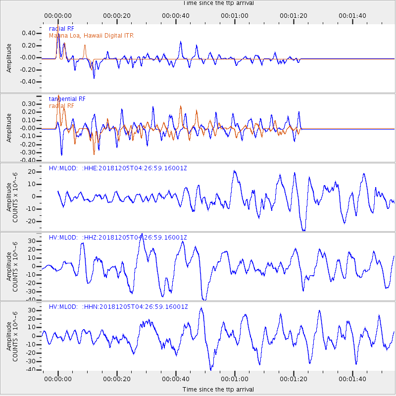
Signal To Noise
| Channel | StoN | STA | LTA |
| HV:MLOD: :HHZ:20181205T04:26:59.16001Z | 2.5892525 | 4.353329E-6 | 1.6813074E-6 |
| HV:MLOD: :HHN:20181205T04:26:59.16001Z | 0.93418336 | 3.124239E-6 | 3.344353E-6 |
| HV:MLOD: :HHE:20181205T04:26:59.16001Z | 0.8379634 | 2.177024E-6 | 2.5979944E-6 |
| Arrivals |
| Ps | 2.5 SECOND |
| PpPs | 10.0 SECOND |
| PsPs/PpSs | 12 SECOND |


