You are here: Home > Network List > NN - Western Great Basin/Eastern Sierra Nevada Stations List
> Station OMMB Old Mammoth Mine, surface, wgs-84 > Earthquake Result Viewer
OMMB Old Mammoth Mine, surface, wgs-84 - Earthquake Result Viewer
| Earthquake location: |
Southeast Of Loyalty Islands |
| Earthquake latitude/longitude: |
-22.0/169.4 |
| Earthquake time(UTC): |
2018/12/05 (339) 04:18:08 GMT |
| Earthquake Depth: |
10 km |
| Earthquake Magnitude: |
7.5 Mww |
| Earthquake Catalog/Contributor: |
NEIC PDE/us |
|
| Network: |
NN Western Great Basin/Eastern Sierra Nevada |
| Station: |
OMMB Old Mammoth Mine, surface, wgs-84 |
| Lat/Lon: |
37.61 N/119.00 W |
| Elevation: |
2768 m |
|
| Distance: |
89.6 deg |
| Az: |
48.881 deg |
| Baz: |
241.713 deg |
| Ray Param: |
0.041741386 |
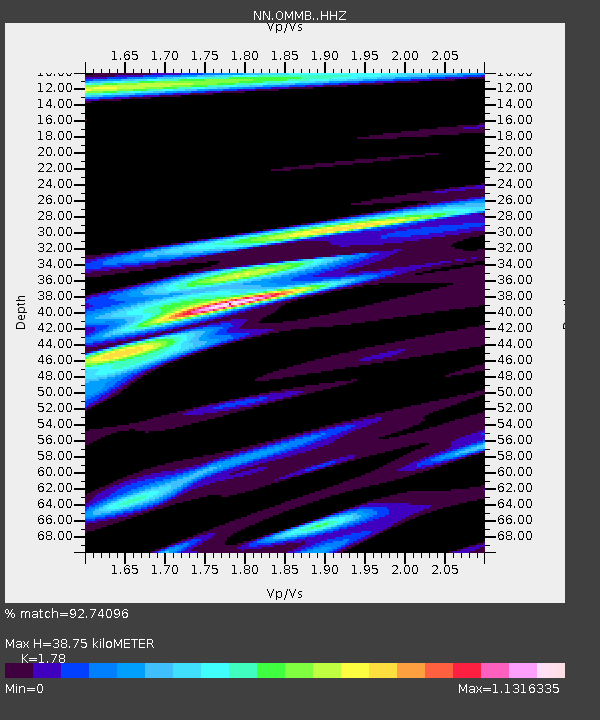
| Estimated Moho Depth: |
38.75 km |
| Estimated Crust Vp/Vs: |
1.78 |
| Assumed Crust Vp: |
6.291 km/s |
| Estimated Crust Vs: |
3.534 km/s |
| Estimated Crust Poisson's Ratio: |
0.27 |
|
| Radial Match: |
92.74096 % |
| Radial Bump: |
400 |
| Transverse Match: |
80.41203 % |
| Transverse Bump: |
400 |
| SOD ConfigId: |
13570011 |
| Insert Time: |
2019-05-02 00:14:14.580 +0000 |
| GWidth: |
2.5 |
| Max Bumps: |
400 |
| Tol: |
0.001 |
|

Signal To Noise
| Channel | StoN | STA | LTA |
| NN:OMMB: :HHZ:20181205T04:30:34.559973Z | 5.5037274 | 1.2688055E-6 | 2.3053566E-7 |
| NN:OMMB: :HHN:20181205T04:30:34.559973Z | 1.7000877 | 4.0478793E-7 | 2.3809828E-7 |
| NN:OMMB: :HHE:20181205T04:30:34.559973Z | 2.2726228 | 4.471529E-7 | 1.9675632E-7 |
| Arrivals |
| Ps | 4.9 SECOND |
| PpPs | 17 SECOND |
| PsPs/PpSs | 22 SECOND |


