You are here: Home > Network List > PY - PFO Array Stations List
> Station BPH01 Pinon Flat Observatory, CA, USA > Earthquake Result Viewer
BPH01 Pinon Flat Observatory, CA, USA - Earthquake Result Viewer
| Earthquake location: |
Southeast Of Loyalty Islands |
| Earthquake latitude/longitude: |
-22.0/169.4 |
| Earthquake time(UTC): |
2018/12/05 (339) 04:18:08 GMT |
| Earthquake Depth: |
10 km |
| Earthquake Magnitude: |
7.5 Mww |
| Earthquake Catalog/Contributor: |
NEIC PDE/us |
|
| Network: |
PY PFO Array |
| Station: |
BPH01 Pinon Flat Observatory, CA, USA |
| Lat/Lon: |
33.61 N/116.46 W |
| Elevation: |
1292 m |
|
| Distance: |
89.6 deg |
| Az: |
53.38 deg |
| Baz: |
243.222 deg |
| Ray Param: |
0.04174606 |
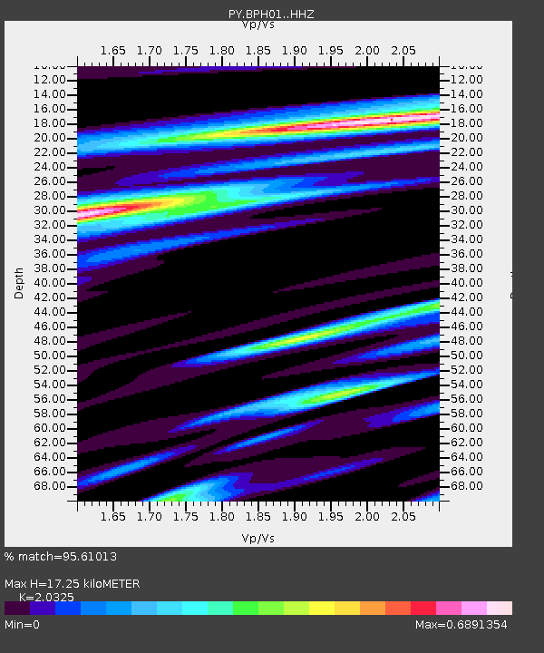
| Estimated Moho Depth: |
17.25 km |
| Estimated Crust Vp/Vs: |
2.03 |
| Assumed Crust Vp: |
6.264 km/s |
| Estimated Crust Vs: |
3.082 km/s |
| Estimated Crust Poisson's Ratio: |
0.34 |
|
| Radial Match: |
95.61013 % |
| Radial Bump: |
368 |
| Transverse Match: |
83.125084 % |
| Transverse Bump: |
400 |
| SOD ConfigId: |
13570011 |
| Insert Time: |
2019-05-02 00:14:54.729 +0000 |
| GWidth: |
2.5 |
| Max Bumps: |
400 |
| Tol: |
0.001 |
|

Signal To Noise
| Channel | StoN | STA | LTA |
| PY:BPH01: :HHZ:20181205T04:30:34.540015Z | 7.305507 | 1.4579034E-6 | 1.9956224E-7 |
| PY:BPH01: :HHN:20181205T04:30:34.540015Z | 1.4601421 | 2.326236E-7 | 1.5931573E-7 |
| PY:BPH01: :HHE:20181205T04:30:34.540015Z | 1.8399422 | 2.6441816E-7 | 1.4371005E-7 |
| Arrivals |
| Ps | 2.9 SECOND |
| PpPs | 8.2 SECOND |
| PsPs/PpSs | 11 SECOND |


