You are here: Home > Network List > TA - USArray Transportable Network (new EarthScope stations) Stations List
> Station A19K Wainwright, AK, USA > Earthquake Result Viewer
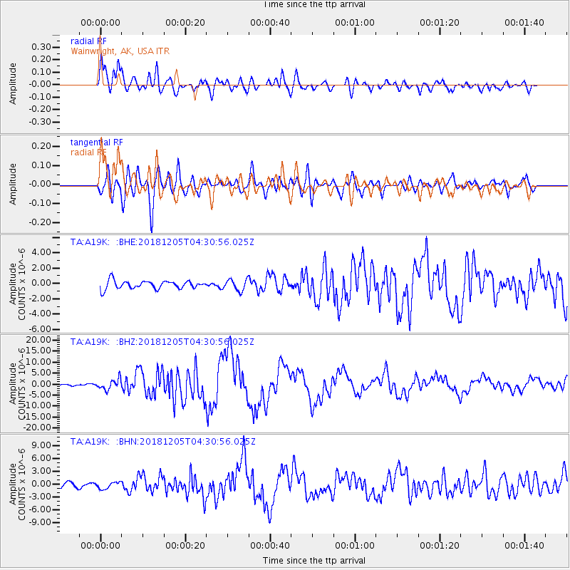
A19K Wainwright, AK, USA - Earthquake Result Viewer

| Earthquake location: |
Southeast Of Loyalty Islands |
| Earthquake latitude/longitude: |
-22.0/169.4 |
| Earthquake time(UTC): |
2018/12/05 (339) 04:18:08 GMT |
| Earthquake Depth: |
10 km |
| Earthquake Magnitude: |
7.5 Mww |
| Earthquake Catalog/Contributor: |
NEIC PDE/us |
|
| Network: |
TA USArray Transportable Network (new EarthScope stations) |
| Station: |
A19K Wainwright, AK, USA |
| Lat/Lon: |
70.20 N/161.07 W |
| Elevation: |
24 m |
|
| Distance: |
94.3 deg |
| Az: |
9.679 deg |
| Baz: |
207.266 deg |
| Ray Param: |
0.041083634 |
| Estimated Moho Depth: |
26.25 km |
| Estimated Crust Vp/Vs: |
2.09 |
| Assumed Crust Vp: |
5.989 km/s |
| Estimated Crust Vs: |
2.866 km/s |
| Estimated Crust Poisson's Ratio: |
0.35 |
|
| Radial Match: |
90.32526 % |
| Radial Bump: |
400 |
| Transverse Match: |
83.18479 % |
| Transverse Bump: |
400 |
| SOD ConfigId: |
13570011 |
| Insert Time: |
2019-05-02 00:15:23.011 +0000 |
| GWidth: |
2.5 |
| Max Bumps: |
400 |
| Tol: |
0.001 |
|
Signal To Noise
| Channel | StoN | STA | LTA |
| TA:A19K: :BHZ:20181205T04:30:56.025Z | 7.6781635 | 2.356693E-6 | 3.0693445E-7 |
| TA:A19K: :BHN:20181205T04:30:56.025Z | 1.2741644 | 7.749339E-7 | 6.0818985E-7 |
| TA:A19K: :BHE:20181205T04:30:56.025Z | 1.3708917 | 7.3694366E-7 | 5.375652E-7 |
| Arrivals |
| Ps | 4.8 SECOND |
| PpPs | 13 SECOND |
| PsPs/PpSs | 18 SECOND |


