You are here: Home > Network List > TA - USArray Transportable Network (new EarthScope stations) Stations List
> Station B18K Kokolik River, AK, USA > Earthquake Result Viewer
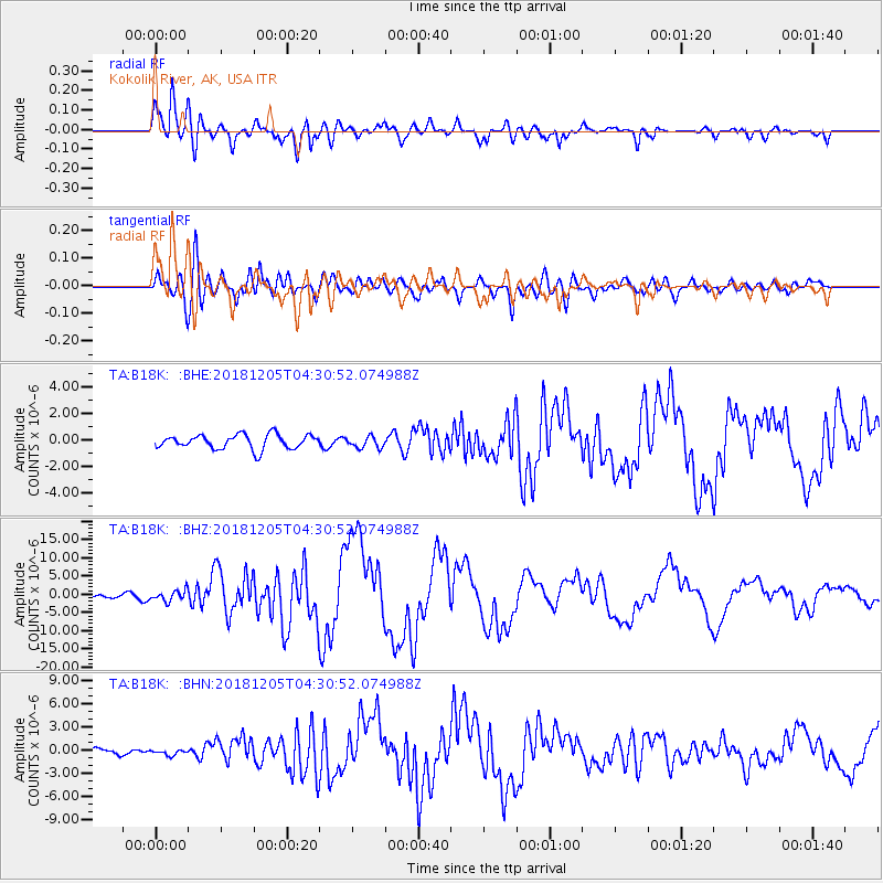
B18K Kokolik River, AK, USA - Earthquake Result Viewer
*The percent match for this event was below the threshold and hence no stack was calculated.
| Earthquake location: |
Southeast Of Loyalty Islands |
| Earthquake latitude/longitude: |
-22.0/169.4 |
| Earthquake time(UTC): |
2018/12/05 (339) 04:18:08 GMT |
| Earthquake Depth: |
10 km |
| Earthquake Magnitude: |
7.5 Mww |
| Earthquake Catalog/Contributor: |
NEIC PDE/us |
|
| Network: |
TA USArray Transportable Network (new EarthScope stations) |
| Station: |
B18K Kokolik River, AK, USA |
| Lat/Lon: |
69.36 N/161.80 W |
| Elevation: |
222 m |
|
| Distance: |
93.4 deg |
| Az: |
9.836 deg |
| Baz: |
206.57 deg |
| Ray Param: |
$rayparam |
*The percent match for this event was below the threshold and hence was not used in the summary stack. |
|
| Radial Match: |
89.445854 % |
| Radial Bump: |
400 |
| Transverse Match: |
82.41237 % |
| Transverse Bump: |
400 |
| SOD ConfigId: |
13570011 |
| Insert Time: |
2019-05-02 00:15:23.340 +0000 |
| GWidth: |
2.5 |
| Max Bumps: |
400 |
| Tol: |
0.001 |
|
Signal To Noise
| Channel | StoN | STA | LTA |
| TA:B18K: :BHZ:20181205T04:30:52.074988Z | 3.1120453 | 1.4820104E-6 | 4.7621745E-7 |
| TA:B18K: :BHN:20181205T04:30:52.074988Z | 0.65161365 | 3.4025393E-7 | 5.221713E-7 |
| TA:B18K: :BHE:20181205T04:30:52.074988Z | 0.8083203 | 4.3461233E-7 | 5.3767343E-7 |
| Arrivals |
| Ps | |
| PpPs | |
| PsPs/PpSs | |


