You are here: Home > Network List > TA - USArray Transportable Network (new EarthScope stations) Stations List
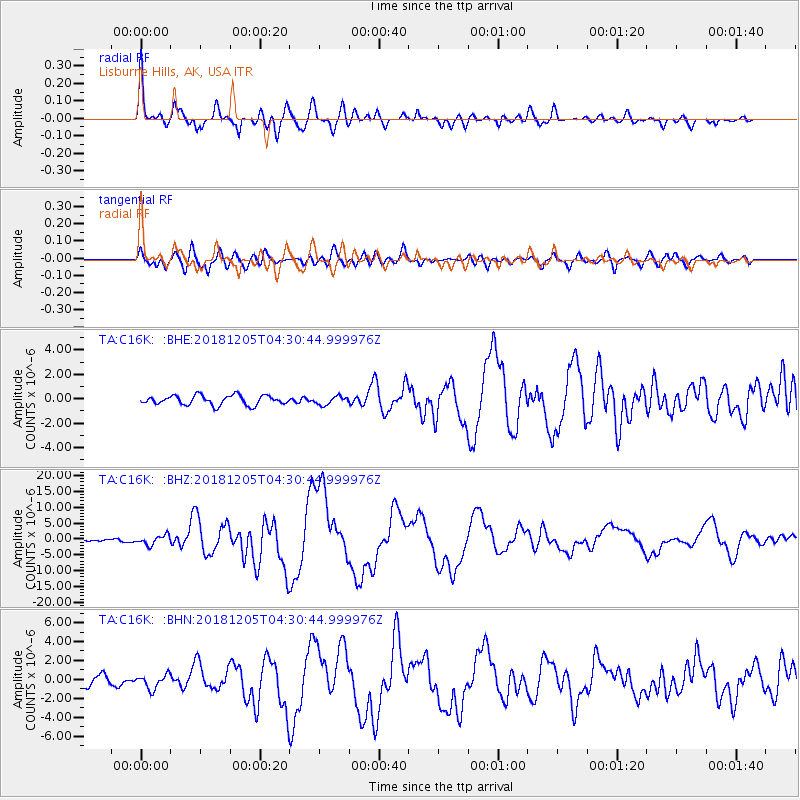
> Station C16K Lisburne Hills, AK, USA > Earthquake Result Viewer
C16K Lisburne Hills, AK, USA - Earthquake Result Viewer
| Earthquake location: |
Southeast Of Loyalty Islands |
| Earthquake latitude/longitude: |
-22.0/169.4 |
| Earthquake time(UTC): |
2018/12/05 (339) 04:18:08 GMT |
| Earthquake Depth: |
10 km |
| Earthquake Magnitude: |
7.5 Mww |
| Earthquake Catalog/Contributor: |
NEIC PDE/us |
|
| Network: |
TA USArray Transportable Network (new EarthScope stations) |
| Station: |
C16K Lisburne Hills, AK, USA |
| Lat/Lon: |
68.27 N/165.34 W |
| Elevation: |
102 m |
|
| Distance: |
91.9 deg |
| Az: |
9.129 deg |
| Baz: |
203.303 deg |
| Ray Param: |
0.04154524 |
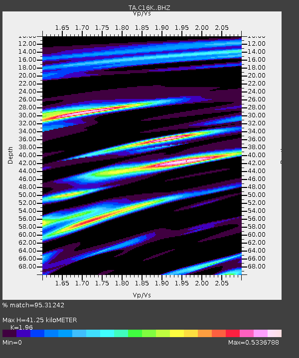
| Estimated Moho Depth: |
41.25 km |
| Estimated Crust Vp/Vs: |
1.96 |
| Assumed Crust Vp: |
5.906 km/s |
| Estimated Crust Vs: |
3.013 km/s |
| Estimated Crust Poisson's Ratio: |
0.32 |
|
| Radial Match: |
95.31242 % |
| Radial Bump: |
400 |
| Transverse Match: |
84.20802 % |
| Transverse Bump: |
400 |
| SOD ConfigId: |
13570011 |
| Insert Time: |
2019-05-02 00:15:27.533 +0000 |
| GWidth: |
2.5 |
| Max Bumps: |
400 |
| Tol: |
0.001 |
|
Signal To Noise
| Channel | StoN | STA | LTA |
| TA:C16K: :BHZ:20181205T04:30:44.999976Z | 3.1909845 | 1.4797049E-6 | 4.6371426E-7 |
| TA:C16K: :BHN:20181205T04:30:44.999976Z | 1.5313858 | 7.4684215E-7 | 4.876904E-7 |
| TA:C16K: :BHE:20181205T04:30:44.999976Z | 0.8839564 | 3.4290798E-7 | 3.879241E-7 |
| Arrivals |
| Ps | 6.8 SECOND |
| PpPs | 20 SECOND |
| PsPs/PpSs | 27 SECOND |


