You are here: Home > Network List > TA - USArray Transportable Network (new EarthScope stations) Stations List
> Station D19K Kuna River, AK, USA > Earthquake Result Viewer
D19K Kuna River, AK, USA - Earthquake Result Viewer
| Earthquake location: |
Southeast Of Loyalty Islands |
| Earthquake latitude/longitude: |
-22.0/169.4 |
| Earthquake time(UTC): |
2018/12/05 (339) 04:18:08 GMT |
| Earthquake Depth: |
10 km |
| Earthquake Magnitude: |
7.5 Mww |
| Earthquake Catalog/Contributor: |
NEIC PDE/us |
|
| Network: |
TA USArray Transportable Network (new EarthScope stations) |
| Station: |
D19K Kuna River, AK, USA |
| Lat/Lon: |
68.49 N/158.12 W |
| Elevation: |
671 m |
|
| Distance: |
93.3 deg |
| Az: |
11.426 deg |
| Baz: |
209.915 deg |
| Ray Param: |
0.041295927 |
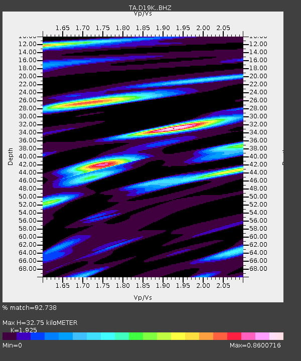
| Estimated Moho Depth: |
32.75 km |
| Estimated Crust Vp/Vs: |
1.92 |
| Assumed Crust Vp: |
6.221 km/s |
| Estimated Crust Vs: |
3.232 km/s |
| Estimated Crust Poisson's Ratio: |
0.32 |
|
| Radial Match: |
92.738 % |
| Radial Bump: |
400 |
| Transverse Match: |
86.03739 % |
| Transverse Bump: |
400 |
| SOD ConfigId: |
13570011 |
| Insert Time: |
2019-05-02 00:15:35.906 +0000 |
| GWidth: |
2.5 |
| Max Bumps: |
400 |
| Tol: |
0.001 |
|

Signal To Noise
| Channel | StoN | STA | LTA |
| TA:D19K: :BHZ:20181205T04:30:51.425024Z | 4.109209 | 1.5862836E-6 | 3.8603136E-7 |
| TA:D19K: :BHN:20181205T04:30:51.425024Z | 1.597797 | 3.4958205E-7 | 2.1879002E-7 |
| TA:D19K: :BHE:20181205T04:30:51.425024Z | 0.85647213 | 2.239151E-7 | 2.6143886E-7 |
| Arrivals |
| Ps | 5.0 SECOND |
| PpPs | 15 SECOND |
| PsPs/PpSs | 20 SECOND |


