You are here: Home > Network List > TA - USArray Transportable Network (new EarthScope stations) Stations List
> Station F30M Barrier River, YT, CAN > Earthquake Result Viewer
F30M Barrier River, YT, CAN - Earthquake Result Viewer
| Earthquake location: |
Southeast Of Loyalty Islands |
| Earthquake latitude/longitude: |
-22.0/169.4 |
| Earthquake time(UTC): |
2018/12/05 (339) 04:18:08 GMT |
| Earthquake Depth: |
10 km |
| Earthquake Magnitude: |
7.5 Mww |
| Earthquake Catalog/Contributor: |
NEIC PDE/us |
|
| Network: |
TA USArray Transportable Network (new EarthScope stations) |
| Station: |
F30M Barrier River, YT, CAN |
| Lat/Lon: |
67.61 N/135.79 W |
| Elevation: |
414 m |
|
| Distance: |
98.0 deg |
| Az: |
18.419 deg |
| Baz: |
229.959 deg |
| Ray Param: |
0.040054657 |
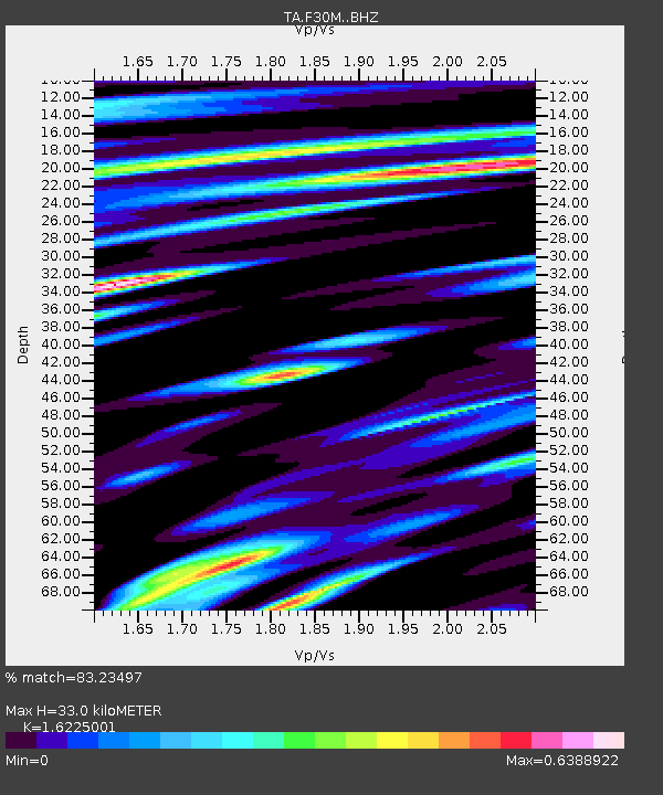
| Estimated Moho Depth: |
33.0 km |
| Estimated Crust Vp/Vs: |
1.62 |
| Assumed Crust Vp: |
6.171 km/s |
| Estimated Crust Vs: |
3.804 km/s |
| Estimated Crust Poisson's Ratio: |
0.19 |
|
| Radial Match: |
83.23497 % |
| Radial Bump: |
400 |
| Transverse Match: |
72.763275 % |
| Transverse Bump: |
400 |
| SOD ConfigId: |
13570011 |
| Insert Time: |
2019-05-02 00:15:59.786 +0000 |
| GWidth: |
2.5 |
| Max Bumps: |
400 |
| Tol: |
0.001 |
|

Signal To Noise
| Channel | StoN | STA | LTA |
| TA:F30M: :BHZ:20181205T04:31:12.675024Z | 4.506587 | 1.2969792E-6 | 2.8779633E-7 |
| TA:F30M: :BHN:20181205T04:31:12.675024Z | 1.4658921 | 6.501158E-7 | 4.43495E-7 |
| TA:F30M: :BHE:20181205T04:31:12.675024Z | 0.64238364 | 3.702504E-7 | 5.763696E-7 |
| Arrivals |
| Ps | 3.4 SECOND |
| PpPs | 14 SECOND |
| PsPs/PpSs | 17 SECOND |


