You are here: Home > Network List > TA - USArray Transportable Network (new EarthScope stations) Stations List
> Station H17K Granite Mountain, AK, USA > Earthquake Result Viewer
H17K Granite Mountain, AK, USA - Earthquake Result Viewer
| Earthquake location: |
Southeast Of Loyalty Islands |
| Earthquake latitude/longitude: |
-22.0/169.4 |
| Earthquake time(UTC): |
2018/12/05 (339) 04:18:08 GMT |
| Earthquake Depth: |
10 km |
| Earthquake Magnitude: |
7.5 Mww |
| Earthquake Catalog/Contributor: |
NEIC PDE/us |
|
| Network: |
TA USArray Transportable Network (new EarthScope stations) |
| Station: |
H17K Granite Mountain, AK, USA |
| Lat/Lon: |
64.94 N/159.91 W |
| Elevation: |
396 m |
|
| Distance: |
89.8 deg |
| Az: |
12.538 deg |
| Baz: |
208.235 deg |
| Ray Param: |
0.04171964 |
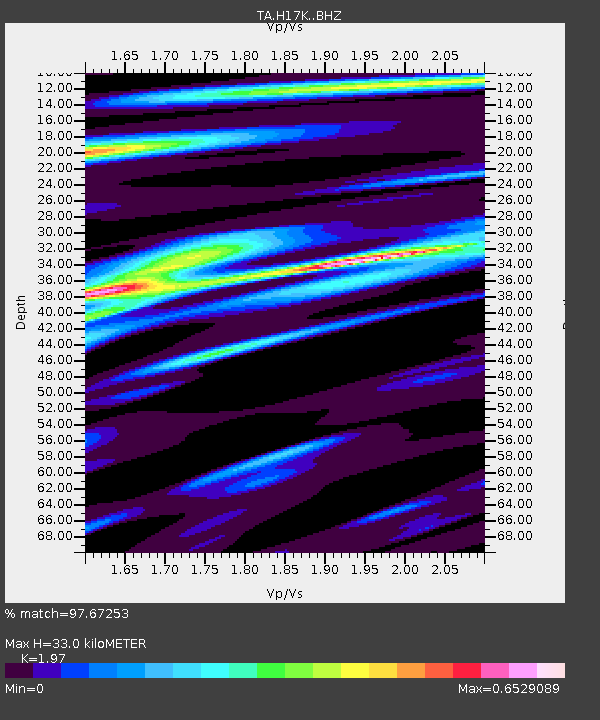
| Estimated Moho Depth: |
33.0 km |
| Estimated Crust Vp/Vs: |
1.97 |
| Assumed Crust Vp: |
6.1 km/s |
| Estimated Crust Vs: |
3.096 km/s |
| Estimated Crust Poisson's Ratio: |
0.33 |
|
| Radial Match: |
97.67253 % |
| Radial Bump: |
400 |
| Transverse Match: |
85.928024 % |
| Transverse Bump: |
400 |
| SOD ConfigId: |
13570011 |
| Insert Time: |
2019-05-02 00:16:10.004 +0000 |
| GWidth: |
2.5 |
| Max Bumps: |
400 |
| Tol: |
0.001 |
|

Signal To Noise
| Channel | StoN | STA | LTA |
| TA:H17K: :BHZ:20181205T04:30:35.425024Z | 3.1717803 | 1.3915225E-6 | 4.387197E-7 |
| TA:H17K: :BHN:20181205T04:30:35.425024Z | 0.9239876 | 3.608305E-7 | 3.9051443E-7 |
| TA:H17K: :BHE:20181205T04:30:35.425024Z | 0.99033576 | 3.9291643E-7 | 3.9675075E-7 |
| Arrivals |
| Ps | 5.3 SECOND |
| PpPs | 16 SECOND |
| PsPs/PpSs | 21 SECOND |


