You are here: Home > Network List > TA - USArray Transportable Network (new EarthScope stations) Stations List
> Station J19K Poorman, AK, USA > Earthquake Result Viewer
J19K Poorman, AK, USA - Earthquake Result Viewer
| Earthquake location: |
Southeast Of Loyalty Islands |
| Earthquake latitude/longitude: |
-22.0/169.4 |
| Earthquake time(UTC): |
2018/12/05 (339) 04:18:08 GMT |
| Earthquake Depth: |
10 km |
| Earthquake Magnitude: |
7.5 Mww |
| Earthquake Catalog/Contributor: |
NEIC PDE/us |
|
| Network: |
TA USArray Transportable Network (new EarthScope stations) |
| Station: |
J19K Poorman, AK, USA |
| Lat/Lon: |
63.99 N/155.62 W |
| Elevation: |
389 m |
|
| Distance: |
89.9 deg |
| Az: |
14.622 deg |
| Baz: |
212.109 deg |
| Ray Param: |
0.041711334 |
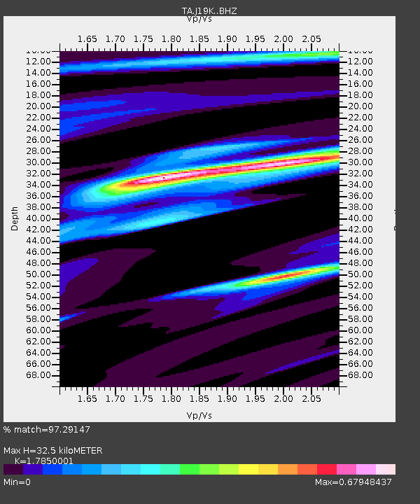
| Estimated Moho Depth: |
32.5 km |
| Estimated Crust Vp/Vs: |
1.79 |
| Assumed Crust Vp: |
6.438 km/s |
| Estimated Crust Vs: |
3.607 km/s |
| Estimated Crust Poisson's Ratio: |
0.27 |
|
| Radial Match: |
97.29147 % |
| Radial Bump: |
269 |
| Transverse Match: |
81.09611 % |
| Transverse Bump: |
400 |
| SOD ConfigId: |
13570011 |
| Insert Time: |
2019-05-02 00:16:26.988 +0000 |
| GWidth: |
2.5 |
| Max Bumps: |
400 |
| Tol: |
0.001 |
|

Signal To Noise
| Channel | StoN | STA | LTA |
| TA:J19K: :BHZ:20181205T04:30:35.975012Z | 3.3085916 | 1.5314455E-6 | 4.628693E-7 |
| TA:J19K: :BHN:20181205T04:30:35.975012Z | 0.55341005 | 3.3362647E-7 | 6.028558E-7 |
| TA:J19K: :BHE:20181205T04:30:35.975012Z | 0.28403154 | 1.3791649E-7 | 4.8556745E-7 |
| Arrivals |
| Ps | 4.0 SECOND |
| PpPs | 14 SECOND |
| PsPs/PpSs | 18 SECOND |


