You are here: Home > Network List > TA - USArray Transportable Network (new EarthScope stations) Stations List
> Station E24A Baker, MT, USA > Earthquake Result Viewer
E24A Baker, MT, USA - Earthquake Result Viewer
| Earthquake location: |
Near S. Coast Of Honshu, Japan |
| Earthquake latitude/longitude: |
33.2/137.9 |
| Earthquake time(UTC): |
2009/08/09 (221) 10:55:55 GMT |
| Earthquake Depth: |
297 km |
| Earthquake Magnitude: |
6.5 MB, 7.1 MW, 7.1 MW |
| Earthquake Catalog/Contributor: |
WHDF/NEIC |
|
| Network: |
TA USArray Transportable Network (new EarthScope stations) |
| Station: |
E24A Baker, MT, USA |
| Lat/Lon: |
46.56 N/104.31 W |
| Elevation: |
912 m |
|
| Distance: |
82.8 deg |
| Az: |
37.984 deg |
| Baz: |
311.573 deg |
| Ray Param: |
0.045840338 |
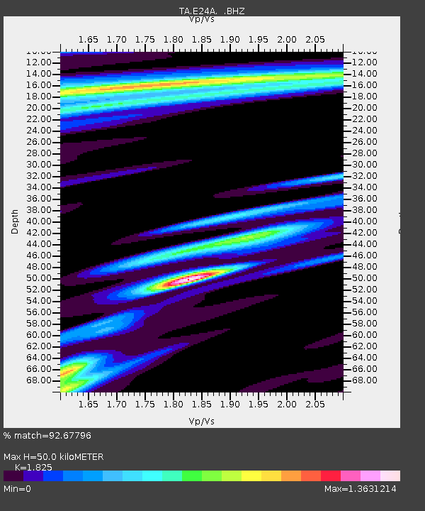
| Estimated Moho Depth: |
50.0 km |
| Estimated Crust Vp/Vs: |
1.83 |
| Assumed Crust Vp: |
6.438 km/s |
| Estimated Crust Vs: |
3.527 km/s |
| Estimated Crust Poisson's Ratio: |
0.29 |
|
| Radial Match: |
92.67796 % |
| Radial Bump: |
388 |
| Transverse Match: |
77.96426 % |
| Transverse Bump: |
400 |
| SOD ConfigId: |
2622 |
| Insert Time: |
2010-03-06 18:30:14.458 +0000 |
| GWidth: |
2.5 |
| Max Bumps: |
400 |
| Tol: |
0.001 |
|

Signal To Noise
| Channel | StoN | STA | LTA |
| TA:E24A: :BHZ:20090809T11:07:15.875015Z | 61.69406 | 7.866454E-6 | 1.2750749E-7 |
| TA:E24A: :BHN:20090809T11:07:15.875015Z | 11.753758 | 2.122886E-6 | 1.8061337E-7 |
| TA:E24A: :BHE:20090809T11:07:15.875015Z | 5.91838 | 1.9168863E-6 | 3.23887E-7 |
| Arrivals |
| Ps | 6.6 SECOND |
| PpPs | 21 SECOND |
| PsPs/PpSs | 28 SECOND |


