You are here: Home > Network List > TA - USArray Transportable Network (new EarthScope stations) Stations List
> Station E24A Baker, MT, USA > Earthquake Result Viewer
E24A Baker, MT, USA - Earthquake Result Viewer
| Earthquake location: |
Southeast Of Honshu, Japan |
| Earthquake latitude/longitude: |
32.8/140.4 |
| Earthquake time(UTC): |
2009/08/12 (224) 22:48:51 GMT |
| Earthquake Depth: |
53 km |
| Earthquake Magnitude: |
6.2 MB, 6.6 MW, 6.6 MW |
| Earthquake Catalog/Contributor: |
WHDF/NEIC |
|
| Network: |
TA USArray Transportable Network (new EarthScope stations) |
| Station: |
E24A Baker, MT, USA |
| Lat/Lon: |
46.56 N/104.31 W |
| Elevation: |
912 m |
|
| Distance: |
81.8 deg |
| Az: |
39.068 deg |
| Baz: |
309.728 deg |
| Ray Param: |
0.047217272 |
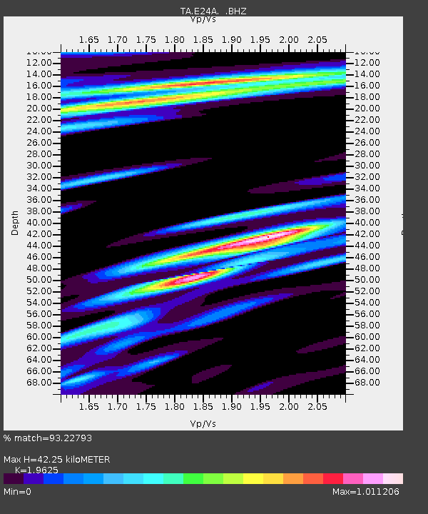
| Estimated Moho Depth: |
42.25 km |
| Estimated Crust Vp/Vs: |
1.96 |
| Assumed Crust Vp: |
6.438 km/s |
| Estimated Crust Vs: |
3.28 km/s |
| Estimated Crust Poisson's Ratio: |
0.32 |
|
| Radial Match: |
93.22793 % |
| Radial Bump: |
327 |
| Transverse Match: |
73.185524 % |
| Transverse Bump: |
400 |
| SOD ConfigId: |
2622 |
| Insert Time: |
2010-03-06 18:30:15.861 +0000 |
| GWidth: |
2.5 |
| Max Bumps: |
400 |
| Tol: |
0.001 |
|

Signal To Noise
| Channel | StoN | STA | LTA |
| TA:E24A: :BHZ:20090812T23:00:33.750017Z | 28.642004 | 2.9726468E-6 | 1.0378627E-7 |
| TA:E24A: :BHN:20090812T23:00:33.750017Z | 4.1740947 | 7.9719604E-7 | 1.9098657E-7 |
| TA:E24A: :BHE:20090812T23:00:33.750017Z | 3.2377975 | 6.8436685E-7 | 2.1136802E-7 |
| Arrivals |
| Ps | 6.5 SECOND |
| PpPs | 19 SECOND |
| PsPs/PpSs | 25 SECOND |


