You are here: Home > Network List > TA - USArray Transportable Network (new EarthScope stations) Stations List
> Station M15K Kasigluk River, AK, USA > Earthquake Result Viewer
M15K Kasigluk River, AK, USA - Earthquake Result Viewer
| Earthquake location: |
Southeast Of Loyalty Islands |
| Earthquake latitude/longitude: |
-22.0/169.4 |
| Earthquake time(UTC): |
2018/12/05 (339) 04:18:08 GMT |
| Earthquake Depth: |
10 km |
| Earthquake Magnitude: |
7.5 Mww |
| Earthquake Catalog/Contributor: |
NEIC PDE/us |
|
| Network: |
TA USArray Transportable Network (new EarthScope stations) |
| Station: |
M15K Kasigluk River, AK, USA |
| Lat/Lon: |
60.69 N/160.69 W |
| Elevation: |
210 m |
|
| Distance: |
85.9 deg |
| Az: |
14.219 deg |
| Baz: |
207.61 deg |
| Ray Param: |
0.044462666 |
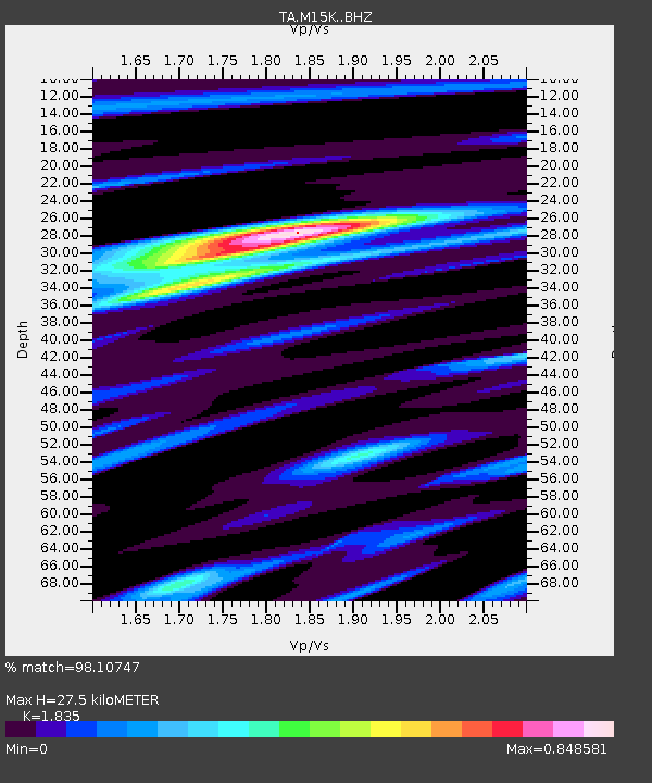
| Estimated Moho Depth: |
27.5 km |
| Estimated Crust Vp/Vs: |
1.84 |
| Assumed Crust Vp: |
6.182 km/s |
| Estimated Crust Vs: |
3.369 km/s |
| Estimated Crust Poisson's Ratio: |
0.29 |
|
| Radial Match: |
98.10747 % |
| Radial Bump: |
356 |
| Transverse Match: |
84.30972 % |
| Transverse Bump: |
400 |
| SOD ConfigId: |
13570011 |
| Insert Time: |
2019-05-02 00:16:46.734 +0000 |
| GWidth: |
2.5 |
| Max Bumps: |
400 |
| Tol: |
0.001 |
|

Signal To Noise
| Channel | StoN | STA | LTA |
| TA:M15K: :BHZ:20181205T04:30:16.650Z | 5.1930847 | 3.200454E-6 | 6.162915E-7 |
| TA:M15K: :BHN:20181205T04:30:16.650Z | 2.279607 | 1.152221E-6 | 5.054472E-7 |
| TA:M15K: :BHE:20181205T04:30:16.650Z | 0.98452735 | 8.5197496E-7 | 8.653644E-7 |
| Arrivals |
| Ps | 3.8 SECOND |
| PpPs | 12 SECOND |
| PsPs/PpSs | 16 SECOND |


