You are here: Home > Network List > TA - USArray Transportable Network (new EarthScope stations) Stations List
> Station M19K Big River Lodge, Big River, AK, USA > Earthquake Result Viewer
M19K Big River Lodge, Big River, AK, USA - Earthquake Result Viewer
| Earthquake location: |
Southeast Of Loyalty Islands |
| Earthquake latitude/longitude: |
-22.0/169.4 |
| Earthquake time(UTC): |
2018/12/05 (339) 04:18:08 GMT |
| Earthquake Depth: |
10 km |
| Earthquake Magnitude: |
7.5 Mww |
| Earthquake Catalog/Contributor: |
NEIC PDE/us |
|
| Network: |
TA USArray Transportable Network (new EarthScope stations) |
| Station: |
M19K Big River Lodge, Big River, AK, USA |
| Lat/Lon: |
61.90 N/154.39 W |
| Elevation: |
521 m |
|
| Distance: |
88.4 deg |
| Az: |
16.228 deg |
| Baz: |
213.226 deg |
| Ray Param: |
0.042583067 |
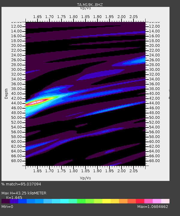
| Estimated Moho Depth: |
43.25 km |
| Estimated Crust Vp/Vs: |
1.64 |
| Assumed Crust Vp: |
6.566 km/s |
| Estimated Crust Vs: |
3.992 km/s |
| Estimated Crust Poisson's Ratio: |
0.21 |
|
| Radial Match: |
95.037094 % |
| Radial Bump: |
300 |
| Transverse Match: |
86.87066 % |
| Transverse Bump: |
400 |
| SOD ConfigId: |
13570011 |
| Insert Time: |
2019-05-02 00:16:49.585 +0000 |
| GWidth: |
2.5 |
| Max Bumps: |
400 |
| Tol: |
0.001 |
|

Signal To Noise
| Channel | StoN | STA | LTA |
| TA:M19K: :BHZ:20181205T04:30:29.124976Z | 5.6084223 | 2.9619025E-6 | 5.2811686E-7 |
| TA:M19K: :BHN:20181205T04:30:29.124976Z | 0.97461224 | 5.7564785E-7 | 5.9064297E-7 |
| TA:M19K: :BHE:20181205T04:30:29.124976Z | 2.1620681 | 9.5165126E-7 | 4.4015786E-7 |
| Arrivals |
| Ps | 4.4 SECOND |
| PpPs | 17 SECOND |
| PsPs/PpSs | 21 SECOND |


