You are here: Home > Network List > TA - USArray Transportable Network (new EarthScope stations) Stations List
> Station E24A Baker, MT, USA > Earthquake Result Viewer
E24A Baker, MT, USA - Earthquake Result Viewer
| Earthquake location: |
South Of Panama |
| Earthquake latitude/longitude: |
6.7/-82.6 |
| Earthquake time(UTC): |
2009/10/22 (295) 00:51:39 GMT |
| Earthquake Depth: |
18 km |
| Earthquake Magnitude: |
5.5 MB, 5.4 MS, 5.9 MW, 5.9 MW |
| Earthquake Catalog/Contributor: |
WHDF/NEIC |
|
| Network: |
TA USArray Transportable Network (new EarthScope stations) |
| Station: |
E24A Baker, MT, USA |
| Lat/Lon: |
46.56 N/104.31 W |
| Elevation: |
912 m |
|
| Distance: |
43.9 deg |
| Az: |
338.372 deg |
| Baz: |
147.959 deg |
| Ray Param: |
0.07224752 |
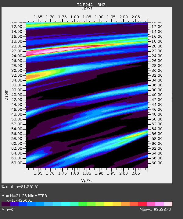
| Estimated Moho Depth: |
21.25 km |
| Estimated Crust Vp/Vs: |
1.74 |
| Assumed Crust Vp: |
6.438 km/s |
| Estimated Crust Vs: |
3.694 km/s |
| Estimated Crust Poisson's Ratio: |
0.25 |
|
| Radial Match: |
81.55151 % |
| Radial Bump: |
389 |
| Transverse Match: |
65.49614 % |
| Transverse Bump: |
400 |
| SOD ConfigId: |
2622 |
| Insert Time: |
2010-03-06 18:30:21.377 +0000 |
| GWidth: |
2.5 |
| Max Bumps: |
400 |
| Tol: |
0.001 |
|

Signal To Noise
| Channel | StoN | STA | LTA |
| TA:E24A: :BHZ:20091022T00:59:13.600015Z | 3.7988024 | 8.2801427E-7 | 2.1796718E-7 |
| TA:E24A: :BHN:20091022T00:59:13.600015Z | 2.4003015 | 7.568701E-7 | 3.1532295E-7 |
| TA:E24A: :BHE:20091022T00:59:13.600015Z | 1.03026 | 8.1667855E-7 | 7.926917E-7 |
| Arrivals |
| Ps | 2.6 SECOND |
| PpPs | 8.5 SECOND |
| PsPs/PpSs | 11 SECOND |


