You are here: Home > Network List > TA - USArray Transportable Network (new EarthScope stations) Stations List
> Station U35K Hyder, AK, USA > Earthquake Result Viewer
U35K Hyder, AK, USA - Earthquake Result Viewer
| Earthquake location: |
Southeast Of Loyalty Islands |
| Earthquake latitude/longitude: |
-22.0/169.4 |
| Earthquake time(UTC): |
2018/12/05 (339) 04:18:08 GMT |
| Earthquake Depth: |
10 km |
| Earthquake Magnitude: |
7.5 Mww |
| Earthquake Catalog/Contributor: |
NEIC PDE/us |
|
| Network: |
TA USArray Transportable Network (new EarthScope stations) |
| Station: |
U35K Hyder, AK, USA |
| Lat/Lon: |
55.92 N/130.03 W |
| Elevation: |
17 m |
|
| Distance: |
92.9 deg |
| Az: |
29.391 deg |
| Baz: |
234.014 deg |
| Ray Param: |
0.04137078 |
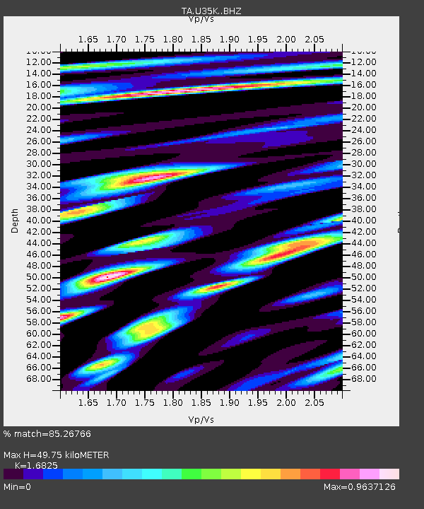
| Estimated Moho Depth: |
49.75 km |
| Estimated Crust Vp/Vs: |
1.68 |
| Assumed Crust Vp: |
6.545 km/s |
| Estimated Crust Vs: |
3.89 km/s |
| Estimated Crust Poisson's Ratio: |
0.23 |
|
| Radial Match: |
85.26766 % |
| Radial Bump: |
400 |
| Transverse Match: |
75.14636 % |
| Transverse Bump: |
400 |
| SOD ConfigId: |
13570011 |
| Insert Time: |
2019-05-02 00:17:32.885 +0000 |
| GWidth: |
2.5 |
| Max Bumps: |
400 |
| Tol: |
0.001 |
|

Signal To Noise
| Channel | StoN | STA | LTA |
| TA:U35K: :BHZ:20181205T04:30:49.749976Z | 3.531253 | 1.425638E-6 | 4.037201E-7 |
| TA:U35K: :BHN:20181205T04:30:49.749976Z | 1.76502 | 5.4411805E-7 | 3.082787E-7 |
| TA:U35K: :BHE:20181205T04:30:49.749976Z | 1.0731053 | 3.5038357E-7 | 3.265137E-7 |
| Arrivals |
| Ps | 5.3 SECOND |
| PpPs | 20 SECOND |
| PsPs/PpSs | 25 SECOND |


