You are here: Home > Network List > UO - University of Oregon Regional Network Stations List
> Station DFAZ Toketee, OR, USA > Earthquake Result Viewer
DFAZ Toketee, OR, USA - Earthquake Result Viewer
| Earthquake location: |
Southeast Of Loyalty Islands |
| Earthquake latitude/longitude: |
-22.0/169.4 |
| Earthquake time(UTC): |
2018/12/05 (339) 04:18:08 GMT |
| Earthquake Depth: |
10 km |
| Earthquake Magnitude: |
7.5 Mww |
| Earthquake Catalog/Contributor: |
NEIC PDE/us |
|
| Network: |
UO University of Oregon Regional Network |
| Station: |
DFAZ Toketee, OR, USA |
| Lat/Lon: |
43.24 N/122.11 W |
| Elevation: |
1948 m |
|
| Distance: |
90.3 deg |
| Az: |
42.818 deg |
| Baz: |
239.694 deg |
| Ray Param: |
0.04168555 |
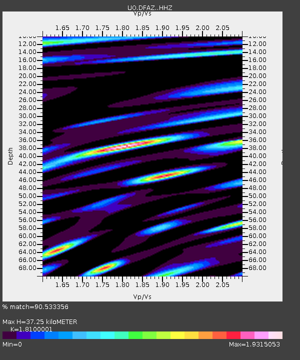
| Estimated Moho Depth: |
37.25 km |
| Estimated Crust Vp/Vs: |
1.81 |
| Assumed Crust Vp: |
6.522 km/s |
| Estimated Crust Vs: |
3.603 km/s |
| Estimated Crust Poisson's Ratio: |
0.28 |
|
| Radial Match: |
90.533356 % |
| Radial Bump: |
400 |
| Transverse Match: |
72.09931 % |
| Transverse Bump: |
400 |
| SOD ConfigId: |
13570011 |
| Insert Time: |
2019-05-02 00:17:48.967 +0000 |
| GWidth: |
2.5 |
| Max Bumps: |
400 |
| Tol: |
0.001 |
|

Signal To Noise
| Channel | StoN | STA | LTA |
| UO:DFAZ: :HHZ:20181205T04:30:37.697974Z | 5.5407696 | 2.3002597E-6 | 4.1515165E-7 |
| UO:DFAZ: :HHN:20181205T04:30:37.697974Z | 1.5438466 | 1.0752227E-6 | 6.9645694E-7 |
| UO:DFAZ: :HHE:20181205T04:30:37.697974Z | 1.1464889 | 9.185109E-7 | 8.0115115E-7 |
| Arrivals |
| Ps | 4.7 SECOND |
| PpPs | 16 SECOND |
| PsPs/PpSs | 20 SECOND |


