You are here: Home > Network List > G - GEOSCOPE Stations List
> Station CLF Chambon la Foret observatory, France > Earthquake Result Viewer
CLF Chambon la Foret observatory, France - Earthquake Result Viewer
| Earthquake location: |
Myanmar |
| Earthquake latitude/longitude: |
20.9/94.6 |
| Earthquake time(UTC): |
2016/08/24 (237) 10:34:55 GMT |
| Earthquake Depth: |
84 km |
| Earthquake Magnitude: |
6.8 MO |
| Earthquake Catalog/Contributor: |
NEIC PDE/NEIC ALERT |
|
| Network: |
G GEOSCOPE |
| Station: |
CLF Chambon la Foret observatory, France |
| Lat/Lon: |
48.03 N/2.26 E |
| Elevation: |
145 m |
|
| Distance: |
76.2 deg |
| Az: |
316.329 deg |
| Baz: |
74.087 deg |
| Ray Param: |
0.05093488 |
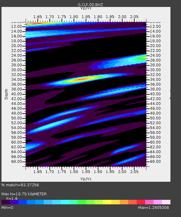
| Estimated Moho Depth: |
10.75 km |
| Estimated Crust Vp/Vs: |
1.60 |
| Assumed Crust Vp: |
6.12 km/s |
| Estimated Crust Vs: |
3.825 km/s |
| Estimated Crust Poisson's Ratio: |
0.18 |
|
| Radial Match: |
93.37256 % |
| Radial Bump: |
400 |
| Transverse Match: |
84.38453 % |
| Transverse Bump: |
400 |
| SOD ConfigId: |
1634031 |
| Insert Time: |
2016-09-07 10:35:49.477 +0000 |
| GWidth: |
2.5 |
| Max Bumps: |
400 |
| Tol: |
0.001 |
|
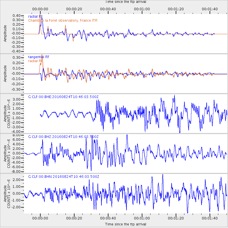
Signal To Noise
| Channel | StoN | STA | LTA |
| G:CLF:00:BHZ:20160824T10:46:03.500Z | 13.200371 | 2.8803954E-6 | 2.1820566E-7 |
| G:CLF:00:BHN:20160824T10:46:03.500Z | 1.2087475 | 4.6497053E-7 | 3.8467132E-7 |
| G:CLF:00:BHE:20160824T10:46:03.500Z | 3.0465002 | 1.2713504E-6 | 4.1731502E-7 |
| Arrivals |
| Ps | 1.1 SECOND |
| PpPs | 4.4 SECOND |
| PsPs/PpSs | 5.5 SECOND |


