You are here: Home > Network List > UO - University of Oregon Regional Network Stations List
> Station MINN McMinnville, OR, USA > Earthquake Result Viewer
MINN McMinnville, OR, USA - Earthquake Result Viewer
| Earthquake location: |
Southeast Of Loyalty Islands |
| Earthquake latitude/longitude: |
-22.0/169.4 |
| Earthquake time(UTC): |
2018/12/05 (339) 04:18:08 GMT |
| Earthquake Depth: |
10 km |
| Earthquake Magnitude: |
7.5 Mww |
| Earthquake Catalog/Contributor: |
NEIC PDE/us |
|
| Network: |
UO University of Oregon Regional Network |
| Station: |
MINN McMinnville, OR, USA |
| Lat/Lon: |
45.21 N/123.26 W |
| Elevation: |
222 m |
|
| Distance: |
90.6 deg |
| Az: |
40.7 deg |
| Baz: |
238.907 deg |
| Ray Param: |
0.04166472 |
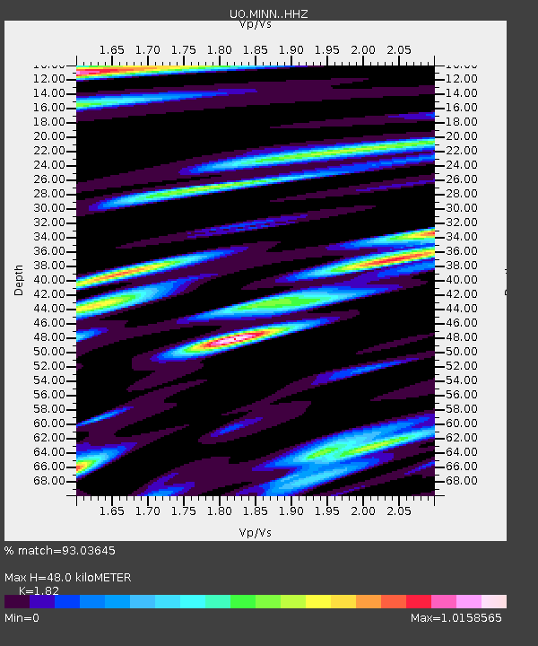
| Estimated Moho Depth: |
48.0 km |
| Estimated Crust Vp/Vs: |
1.82 |
| Assumed Crust Vp: |
6.566 km/s |
| Estimated Crust Vs: |
3.608 km/s |
| Estimated Crust Poisson's Ratio: |
0.28 |
|
| Radial Match: |
93.03645 % |
| Radial Bump: |
400 |
| Transverse Match: |
86.34173 % |
| Transverse Bump: |
400 |
| SOD ConfigId: |
13570011 |
| Insert Time: |
2019-05-02 00:17:54.623 +0000 |
| GWidth: |
2.5 |
| Max Bumps: |
400 |
| Tol: |
0.001 |
|

Signal To Noise
| Channel | StoN | STA | LTA |
| UO:MINN: :HHZ:20181205T04:30:39.04801Z | 4.8806205 | 2.0095988E-6 | 4.1175068E-7 |
| UO:MINN: :HHN:20181205T04:30:39.04801Z | 0.9071488 | 5.594881E-7 | 6.167545E-7 |
| UO:MINN: :HHE:20181205T04:30:39.04801Z | 1.6213858 | 5.086989E-7 | 3.137433E-7 |
| Arrivals |
| Ps | 6.1 SECOND |
| PpPs | 20 SECOND |
| PsPs/PpSs | 26 SECOND |


