You are here: Home > Network List > UO - University of Oregon Regional Network Stations List
> Station WLOO Lebanon, OR, USA > Earthquake Result Viewer
WLOO Lebanon, OR, USA - Earthquake Result Viewer
| Earthquake location: |
Southeast Of Loyalty Islands |
| Earthquake latitude/longitude: |
-22.0/169.4 |
| Earthquake time(UTC): |
2018/12/05 (339) 04:18:08 GMT |
| Earthquake Depth: |
10 km |
| Earthquake Magnitude: |
7.5 Mww |
| Earthquake Catalog/Contributor: |
NEIC PDE/us |
|
| Network: |
UO University of Oregon Regional Network |
| Station: |
WLOO Lebanon, OR, USA |
| Lat/Lon: |
44.52 N/122.74 W |
| Elevation: |
284 m |
|
| Distance: |
90.5 deg |
| Az: |
41.483 deg |
| Baz: |
239.269 deg |
| Ray Param: |
0.04166702 |
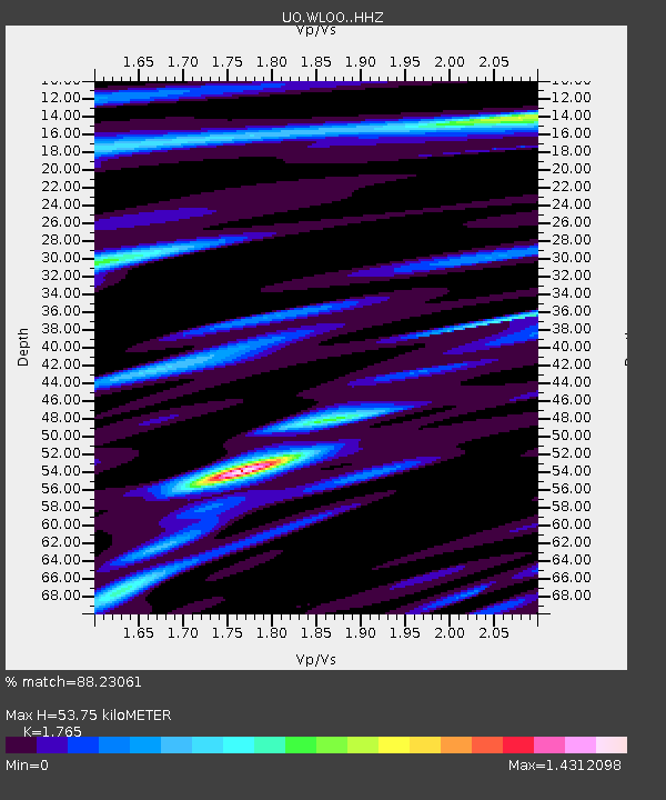
| Estimated Moho Depth: |
53.75 km |
| Estimated Crust Vp/Vs: |
1.76 |
| Assumed Crust Vp: |
6.566 km/s |
| Estimated Crust Vs: |
3.72 km/s |
| Estimated Crust Poisson's Ratio: |
0.26 |
|
| Radial Match: |
88.23061 % |
| Radial Bump: |
400 |
| Transverse Match: |
78.06736 % |
| Transverse Bump: |
400 |
| SOD ConfigId: |
13570011 |
| Insert Time: |
2019-05-02 00:18:00.613 +0000 |
| GWidth: |
2.5 |
| Max Bumps: |
400 |
| Tol: |
0.001 |
|

Signal To Noise
| Channel | StoN | STA | LTA |
| UO:WLOO: :HHZ:20181205T04:30:38.897986Z | 7.376558 | 2.1503124E-6 | 2.915062E-7 |
| UO:WLOO: :HHN:20181205T04:30:38.897986Z | 0.4163393 | 2.9576395E-7 | 7.1039165E-7 |
| UO:WLOO: :HHE:20181205T04:30:38.897986Z | 1.2989775 | 3.6257228E-7 | 2.791213E-7 |
| Arrivals |
| Ps | 6.4 SECOND |
| PpPs | 22 SECOND |
| PsPs/PpSs | 29 SECOND |


