You are here: Home > Network List > US - United States National Seismic Network Stations List
> Station AHID Auburn Hatchery, Idaho, USA > Earthquake Result Viewer
AHID Auburn Hatchery, Idaho, USA - Earthquake Result Viewer
| Earthquake location: |
Southeast Of Loyalty Islands |
| Earthquake latitude/longitude: |
-22.0/169.4 |
| Earthquake time(UTC): |
2018/12/05 (339) 04:18:08 GMT |
| Earthquake Depth: |
10 km |
| Earthquake Magnitude: |
7.5 Mww |
| Earthquake Catalog/Contributor: |
NEIC PDE/us |
|
| Network: |
US United States National Seismic Network |
| Station: |
AHID Auburn Hatchery, Idaho, USA |
| Lat/Lon: |
42.77 N/111.10 W |
| Elevation: |
1960 m |
|
| Distance: |
97.3 deg |
| Az: |
46.872 deg |
| Baz: |
246.921 deg |
| Ray Param: |
0.04026552 |
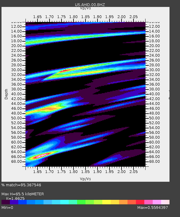
| Estimated Moho Depth: |
65.5 km |
| Estimated Crust Vp/Vs: |
1.66 |
| Assumed Crust Vp: |
6.207 km/s |
| Estimated Crust Vs: |
3.733 km/s |
| Estimated Crust Poisson's Ratio: |
0.22 |
|
| Radial Match: |
95.367546 % |
| Radial Bump: |
400 |
| Transverse Match: |
90.9161 % |
| Transverse Bump: |
400 |
| SOD ConfigId: |
13570011 |
| Insert Time: |
2019-05-02 00:18:01.832 +0000 |
| GWidth: |
2.5 |
| Max Bumps: |
400 |
| Tol: |
0.001 |
|
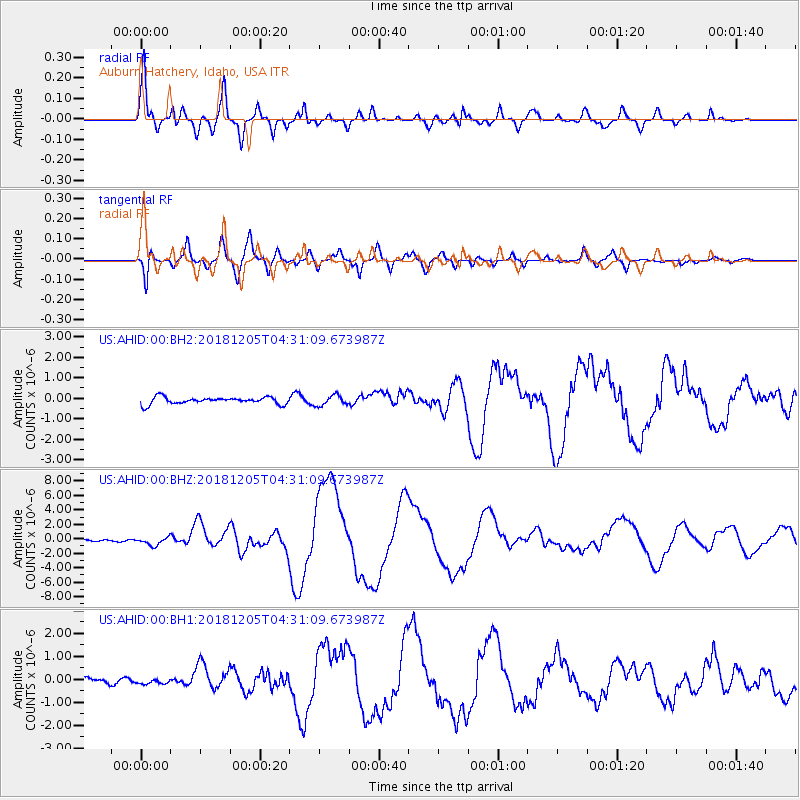
Signal To Noise
| Channel | StoN | STA | LTA |
| US:AHID:00:BHZ:20181205T04:31:09.673987Z | 6.5883436 | 5.69897E-7 | 8.650079E-8 |
| US:AHID:00:BH1:20181205T04:31:09.673987Z | 0.5453394 | 1.1371639E-7 | 2.0852407E-7 |
| US:AHID:00:BH2:20181205T04:31:09.673987Z | 1.4414294 | 2.4636387E-7 | 1.7091637E-7 |
| Arrivals |
| Ps | 7.1 SECOND |
| PpPs | 28 SECOND |
| PsPs/PpSs | 35 SECOND |


