You are here: Home > Network List > UW - Pacific Northwest Regional Seismic Network Stations List
> Station DOSE Dosewallips old TA.C04A, WA > Earthquake Result Viewer
DOSE Dosewallips old TA.C04A, WA - Earthquake Result Viewer
| Earthquake location: |
Southeast Of Loyalty Islands |
| Earthquake latitude/longitude: |
-22.0/169.4 |
| Earthquake time(UTC): |
2018/12/05 (339) 04:18:08 GMT |
| Earthquake Depth: |
10 km |
| Earthquake Magnitude: |
7.5 Mww |
| Earthquake Catalog/Contributor: |
NEIC PDE/us |
|
| Network: |
UW Pacific Northwest Regional Seismic Network |
| Station: |
DOSE Dosewallips old TA.C04A, WA |
| Lat/Lon: |
47.72 N/122.97 W |
| Elevation: |
53 m |
|
| Distance: |
92.0 deg |
| Az: |
38.654 deg |
| Baz: |
239.164 deg |
| Ray Param: |
0.041521166 |
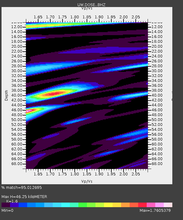
| Estimated Moho Depth: |
46.25 km |
| Estimated Crust Vp/Vs: |
1.60 |
| Assumed Crust Vp: |
6.566 km/s |
| Estimated Crust Vs: |
4.104 km/s |
| Estimated Crust Poisson's Ratio: |
0.18 |
|
| Radial Match: |
95.012695 % |
| Radial Bump: |
400 |
| Transverse Match: |
93.93299 % |
| Transverse Bump: |
400 |
| SOD ConfigId: |
13570011 |
| Insert Time: |
2019-05-02 00:18:14.062 +0000 |
| GWidth: |
2.5 |
| Max Bumps: |
400 |
| Tol: |
0.001 |
|

Signal To Noise
| Channel | StoN | STA | LTA |
| UW:DOSE: :BHZ:20181205T04:30:45.814978Z | 5.423308 | 1.2174581E-6 | 2.2448627E-7 |
| UW:DOSE: :BHN:20181205T04:30:45.814978Z | 1.7856334 | 2.811229E-7 | 1.5743596E-7 |
| UW:DOSE: :BHE:20181205T04:30:45.814978Z | 1.8958812 | 2.9565965E-7 | 1.559484E-7 |
| Arrivals |
| Ps | 4.3 SECOND |
| PpPs | 18 SECOND |
| PsPs/PpSs | 22 SECOND |


