You are here: Home > Network List > YO16 - Yukon Observatory Stations List
> Station KOTA YGS, Kotaneelee Airstrip, YK > Earthquake Result Viewer
KOTA YGS, Kotaneelee Airstrip, YK - Earthquake Result Viewer
| Earthquake location: |
Southeast Of Loyalty Islands |
| Earthquake latitude/longitude: |
-22.0/169.4 |
| Earthquake time(UTC): |
2018/12/05 (339) 04:18:08 GMT |
| Earthquake Depth: |
10 km |
| Earthquake Magnitude: |
7.5 Mww |
| Earthquake Catalog/Contributor: |
NEIC PDE/us |
|
| Network: |
YO Yukon Observatory |
| Station: |
KOTA YGS, Kotaneelee Airstrip, YK |
| Lat/Lon: |
60.13 N/124.05 W |
| Elevation: |
386 m |
|
| Distance: |
97.9 deg |
| Az: |
27.606 deg |
| Baz: |
239.243 deg |
| Ray Param: |
0.04008584 |
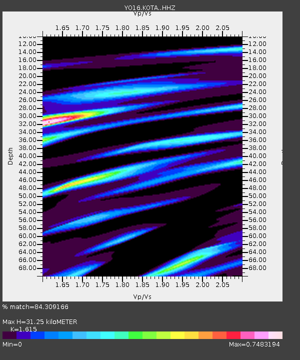
| Estimated Moho Depth: |
31.25 km |
| Estimated Crust Vp/Vs: |
1.62 |
| Assumed Crust Vp: |
6.419 km/s |
| Estimated Crust Vs: |
3.975 km/s |
| Estimated Crust Poisson's Ratio: |
0.19 |
|
| Radial Match: |
84.309166 % |
| Radial Bump: |
400 |
| Transverse Match: |
68.63601 % |
| Transverse Bump: |
400 |
| SOD ConfigId: |
13570011 |
| Insert Time: |
2019-05-02 00:19:04.206 +0000 |
| GWidth: |
2.5 |
| Max Bumps: |
400 |
| Tol: |
0.001 |
|

Signal To Noise
| Channel | StoN | STA | LTA |
| YO:KOTA: :HHZ:20181205T04:31:12.249976Z | 1.7775117 | 1.1984016E-6 | 6.7420183E-7 |
| YO:KOTA: :HHN:20181205T04:31:12.249976Z | 0.3781063 | 2.4104293E-7 | 6.375004E-7 |
| YO:KOTA: :HHE:20181205T04:31:12.249976Z | 1.0173861 | 5.3411503E-7 | 5.2498757E-7 |
| Arrivals |
| Ps | 3.1 SECOND |
| PpPs | 12 SECOND |
| PsPs/PpSs | 16 SECOND |


