You are here: Home > Network List > TS - TERRAscope (Southern California Seismic Network) Stations List
> Station BAR Barrett Dam, California, USA > Earthquake Result Viewer
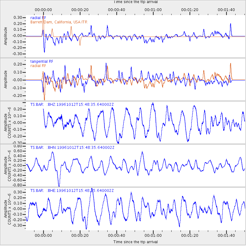
BAR Barrett Dam, California, USA - Earthquake Result Viewer
*The percent match for this event was below the threshold and hence no stack was calculated.
| Earthquake location: |
Solomon Islands |
| Earthquake latitude/longitude: |
-7.2/155.5 |
| Earthquake time(UTC): |
1996/10/12 (286) 15:36:01 GMT |
| Earthquake Depth: |
33 km |
| Earthquake Magnitude: |
5.4 MB, 5.9 MS, 6.0 UNKNOWN, 6.0 MW |
| Earthquake Catalog/Contributor: |
WHDF/NEIC |
|
| Network: |
TS TERRAscope (Southern California Seismic Network) |
| Station: |
BAR Barrett Dam, California, USA |
| Lat/Lon: |
32.68 N/116.67 W |
| Elevation: |
548 m |
|
| Distance: |
92.1 deg |
| Az: |
57.49 deg |
| Baz: |
262.776 deg |
| Ray Param: |
$rayparam |
*The percent match for this event was below the threshold and hence was not used in the summary stack. |
|
| Radial Match: |
38.149654 % |
| Radial Bump: |
400 |
| Transverse Match: |
59.280193 % |
| Transverse Bump: |
400 |
| SOD ConfigId: |
4480 |
| Insert Time: |
2010-02-26 14:01:36.189 +0000 |
| GWidth: |
2.5 |
| Max Bumps: |
400 |
| Tol: |
0.001 |
|
Signal To Noise
| Channel | StoN | STA | LTA |
| TS:BAR: :BHN:19961012T15:48:35.640002Z | 2.350323 | 2.4105648E-7 | 1.02563135E-7 |
| TS:BAR: :BHE:19961012T15:48:35.640002Z | 0.97312915 | 8.5162476E-8 | 8.751405E-8 |
| TS:BAR: :BHZ:19961012T15:48:35.640002Z | 1.6976515 | 1.3369691E-7 | 7.875404E-8 |
| Arrivals |
| Ps | |
| PpPs | |
| PsPs/PpSs | |


