You are here: Home > Network List > CI - Caltech Regional Seismic Network Stations List
> Station TIN Tinemaha, Big Pine, CA, USA > Earthquake Result Viewer
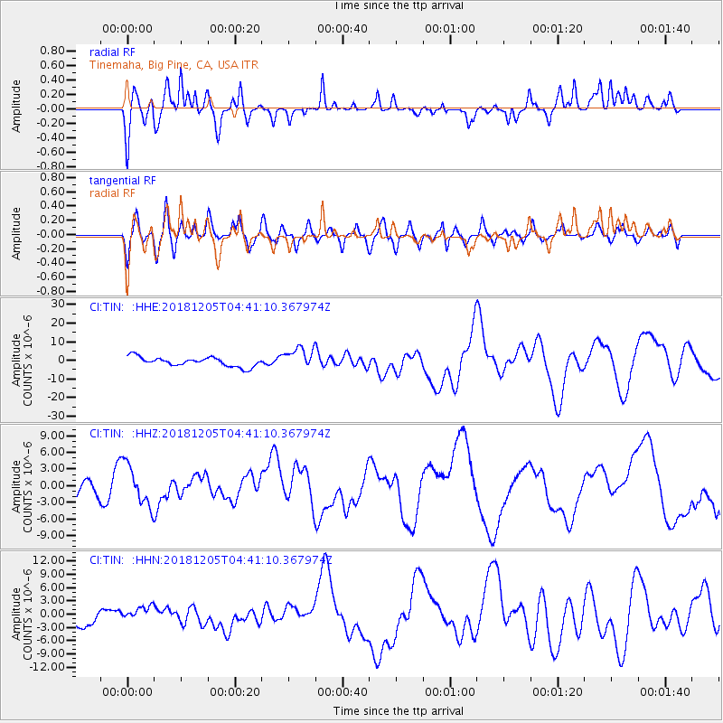
TIN Tinemaha, Big Pine, CA, USA - Earthquake Result Viewer
*The percent match for this event was below the threshold and hence no stack was calculated.
| Earthquake location: |
Southeast Of Loyalty Islands |
| Earthquake latitude/longitude: |
-21.5/169.4 |
| Earthquake time(UTC): |
2018/12/05 (339) 04:28:44 GMT |
| Earthquake Depth: |
10 km |
| Earthquake Magnitude: |
5.9 mb |
| Earthquake Catalog/Contributor: |
NEIC PDE/us |
|
| Network: |
CI Caltech Regional Seismic Network |
| Station: |
TIN Tinemaha, Big Pine, CA, USA |
| Lat/Lon: |
37.05 N/118.23 W |
| Elevation: |
1197 m |
|
| Distance: |
89.6 deg |
| Az: |
49.693 deg |
| Baz: |
242.575 deg |
| Ray Param: |
$rayparam |
*The percent match for this event was below the threshold and hence was not used in the summary stack. |
|
| Radial Match: |
53.11897 % |
| Radial Bump: |
320 |
| Transverse Match: |
45.842346 % |
| Transverse Bump: |
400 |
| SOD ConfigId: |
13570011 |
| Insert Time: |
2019-05-02 00:23:09.090 +0000 |
| GWidth: |
2.5 |
| Max Bumps: |
400 |
| Tol: |
0.001 |
|
Signal To Noise
| Channel | StoN | STA | LTA |
| CI:TIN: :HHZ:20181205T04:41:10.367974Z | 1.5037255 | 3.6809804E-6 | 2.4479073E-6 |
| CI:TIN: :HHN:20181205T04:41:10.367974Z | 0.7106931 | 1.5480125E-6 | 2.178173E-6 |
| CI:TIN: :HHE:20181205T04:41:10.367974Z | 2.3506055 | 5.894487E-6 | 2.5076463E-6 |
| Arrivals |
| Ps | |
| PpPs | |
| PsPs/PpSs | |


