You are here: Home > Network List > IU - Global Seismograph Network (GSN - IRIS/USGS) Stations List
> Station LSZ Lusaka, Zambia > Earthquake Result Viewer
LSZ Lusaka, Zambia - Earthquake Result Viewer
| Earthquake location: |
Myanmar |
| Earthquake latitude/longitude: |
20.9/94.6 |
| Earthquake time(UTC): |
2016/08/24 (237) 10:34:55 GMT |
| Earthquake Depth: |
84 km |
| Earthquake Magnitude: |
6.8 MO |
| Earthquake Catalog/Contributor: |
NEIC PDE/NEIC ALERT |
|
| Network: |
IU Global Seismograph Network (GSN - IRIS/USGS) |
| Station: |
LSZ Lusaka, Zambia |
| Lat/Lon: |
15.28 S/28.19 E |
| Elevation: |
1200 m |
|
| Distance: |
74.4 deg |
| Az: |
246.637 deg |
| Baz: |
62.78 deg |
| Ray Param: |
0.052146353 |
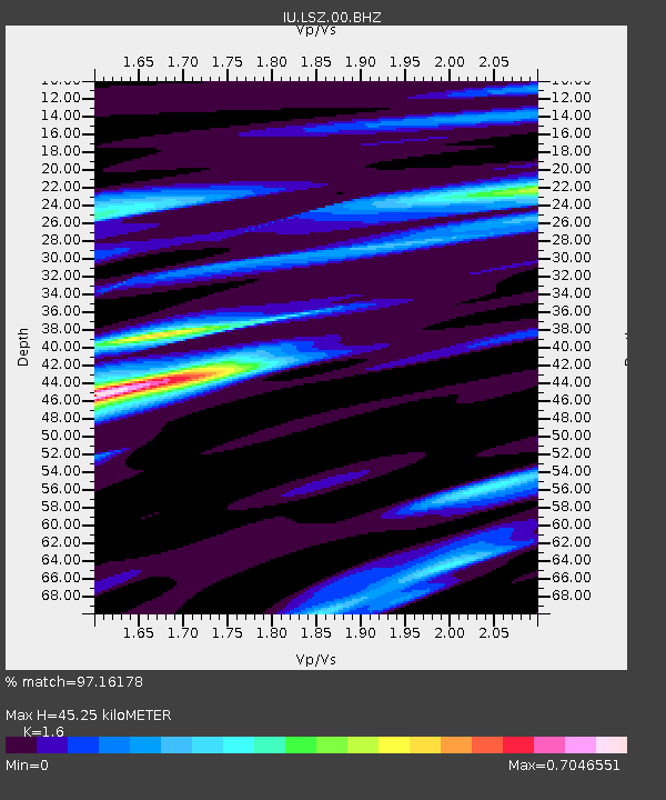
| Estimated Moho Depth: |
45.25 km |
| Estimated Crust Vp/Vs: |
1.60 |
| Assumed Crust Vp: |
6.642 km/s |
| Estimated Crust Vs: |
4.151 km/s |
| Estimated Crust Poisson's Ratio: |
0.18 |
|
| Radial Match: |
97.16178 % |
| Radial Bump: |
378 |
| Transverse Match: |
88.46936 % |
| Transverse Bump: |
400 |
| SOD ConfigId: |
1634031 |
| Insert Time: |
2016-09-07 10:37:15.075 +0000 |
| GWidth: |
2.5 |
| Max Bumps: |
400 |
| Tol: |
0.001 |
|
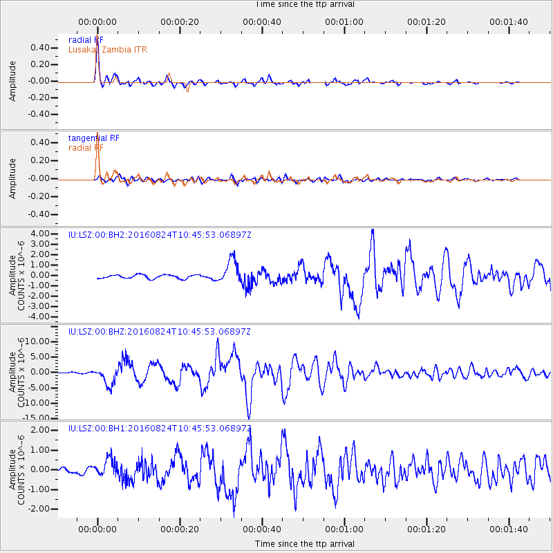
Signal To Noise
| Channel | StoN | STA | LTA |
| IU:LSZ:00:BHZ:20160824T10:45:53.06897Z | 12.493334 | 2.9156947E-6 | 2.3338004E-7 |
| IU:LSZ:00:BH1:20160824T10:45:53.06897Z | 2.7862122 | 4.3967626E-7 | 1.578043E-7 |
| IU:LSZ:00:BH2:20160824T10:45:53.06897Z | 6.6339126 | 1.1815074E-6 | 1.7810115E-7 |
| Arrivals |
| Ps | 4.3 SECOND |
| PpPs | 17 SECOND |
| PsPs/PpSs | 21 SECOND |


