You are here: Home > Network List > TA - USArray Transportable Network (new EarthScope stations) Stations List
> Station E24A Baker, MT, USA > Earthquake Result Viewer
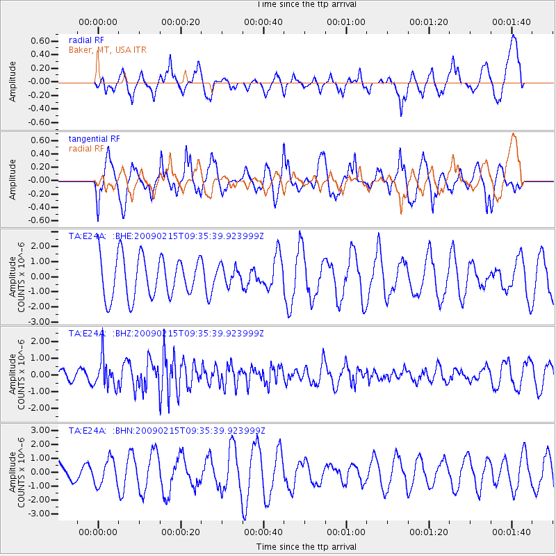
E24A Baker, MT, USA - Earthquake Result Viewer
*The percent match for this event was below the threshold and hence no stack was calculated.
| Earthquake location: |
Near East Coast Of Honshu, Japan |
| Earthquake latitude/longitude: |
40.2/142.2 |
| Earthquake time(UTC): |
2009/02/15 (046) 09:24:31 GMT |
| Earthquake Depth: |
33 km |
| Earthquake Magnitude: |
6.1 MB, 5.5 MS, 5.7 MW, 5.7 MW |
| Earthquake Catalog/Contributor: |
WHDF/NEIC |
|
| Network: |
TA USArray Transportable Network (new EarthScope stations) |
| Station: |
E24A Baker, MT, USA |
| Lat/Lon: |
46.56 N/104.31 W |
| Elevation: |
912 m |
|
| Distance: |
75.2 deg |
| Az: |
40.898 deg |
| Baz: |
313.42 deg |
| Ray Param: |
$rayparam |
*The percent match for this event was below the threshold and hence was not used in the summary stack. |
|
| Radial Match: |
50.110188 % |
| Radial Bump: |
370 |
| Transverse Match: |
48.652367 % |
| Transverse Bump: |
346 |
| SOD ConfigId: |
2658 |
| Insert Time: |
2010-03-06 18:32:07.825 +0000 |
| GWidth: |
2.5 |
| Max Bumps: |
400 |
| Tol: |
0.001 |
|
Signal To Noise
| Channel | StoN | STA | LTA |
| TA:E24A: :BHZ:20090215T09:35:39.923999Z | 2.8020196 | 8.665186E-7 | 3.0924787E-7 |
| TA:E24A: :BHN:20090215T09:35:39.923999Z | 0.98254037 | 9.517374E-7 | 9.686496E-7 |
| TA:E24A: :BHE:20090215T09:35:39.923999Z | 0.45956504 | 6.2326126E-7 | 1.3561981E-6 |
| Arrivals |
| Ps | |
| PpPs | |
| PsPs/PpSs | |


