You are here: Home > Network List > TA - USArray Transportable Network (new EarthScope stations) Stations List
> Station I23K Minto, Yukon-Koyukuk, AK, USA > Earthquake Result Viewer
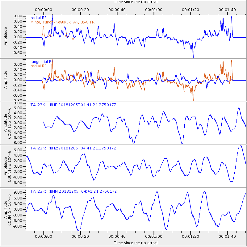
I23K Minto, Yukon-Koyukuk, AK, USA - Earthquake Result Viewer
*The percent match for this event was below the threshold and hence no stack was calculated.
| Earthquake location: |
Southeast Of Loyalty Islands |
| Earthquake latitude/longitude: |
-21.5/169.4 |
| Earthquake time(UTC): |
2018/12/05 (339) 04:28:44 GMT |
| Earthquake Depth: |
10 km |
| Earthquake Magnitude: |
5.9 mb |
| Earthquake Catalog/Contributor: |
NEIC PDE/us |
|
| Network: |
TA USArray Transportable Network (new EarthScope stations) |
| Station: |
I23K Minto, Yukon-Koyukuk, AK, USA |
| Lat/Lon: |
65.15 N/149.36 W |
| Elevation: |
149 m |
|
| Distance: |
92.0 deg |
| Az: |
16.197 deg |
| Baz: |
217.923 deg |
| Ray Param: |
$rayparam |
*The percent match for this event was below the threshold and hence was not used in the summary stack. |
|
| Radial Match: |
51.92466 % |
| Radial Bump: |
400 |
| Transverse Match: |
40.396782 % |
| Transverse Bump: |
376 |
| SOD ConfigId: |
13570011 |
| Insert Time: |
2019-05-02 00:25:44.053 +0000 |
| GWidth: |
2.5 |
| Max Bumps: |
400 |
| Tol: |
0.001 |
|
Signal To Noise
| Channel | StoN | STA | LTA |
| TA:I23K: :BHZ:20181205T04:41:21.275017Z | 0.3029416 | 7.071604E-7 | 2.3343125E-6 |
| TA:I23K: :BHN:20181205T04:41:21.275017Z | 1.2809963 | 3.1404752E-6 | 2.451588E-6 |
| TA:I23K: :BHE:20181205T04:41:21.275017Z | 2.102222 | 3.0745293E-6 | 1.4625142E-6 |
| Arrivals |
| Ps | |
| PpPs | |
| PsPs/PpSs | |


